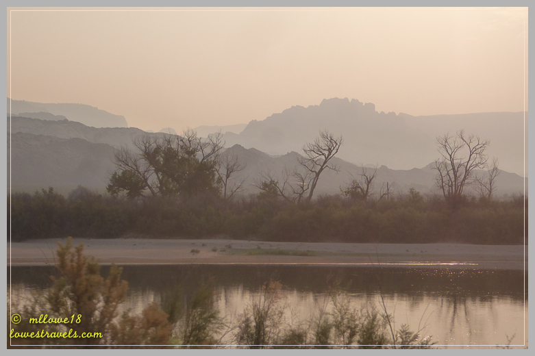
 Continuing our slow move southward, the next stop was at Vernal, Utah. Betsy had some serious mountains to traverse as we crossed the Wyoming-Utah border on the Flaming Gorge-Uintas National Scenic Byway. We saw several major geological formations that exposed the core of the Unita Mountains, and as we neared the summit we paused for a few minutes to take in the breathtaking views of the deep multi-colored canyons:

We’ve driven this section of the byway before, and the unique geologic features never fail to “wow” us. Several signposts can be seen along the roadside that teach motorists the geology of the area. They identify the various rock strata and types of fossils found there, and describe the geologic time period. My previous post contains more photos and information from our last trip through the area.


The city of Vernal and its surrounding area is “dinosaur country”, well known to geologists for the fossilized relics found in the ancient seas that existed here. Our 2016 trip took us to Dinosaur National Monument, where more than 1,500 dinosaur bones and fossils have been found. Click here to read more about the logjam of fossils located at the monument.

Temperatures hovered at or above 95 degrees during our one-week stay. We were initially concerned that the smoke blown here from the California fires would hamper our outdoor activities, but we forged ahead with plans to hike trails that we missed during our last stay. Unfortunately most of my photos are a bit hazy and smoky.
There are many excellent trails here on the ancient floodplain which was once home to dinosaurs. Sticking to our mantra of early starts and lots of water helped us to beat the heat and have the trails practically to ourselves 🙂
Dinosaur Trackway Trail
The reward at the end of the 1.8-mile Dinosaur Trackway Trail is not as obvious as other hikes. Based on plaques along the way, we had to search for the reward: 200-million-year-old dilophosaurus tracks preserved in the slick rock shores of Red Fleet reservoir.
While neither of us is into paleontology, seeing the tracks is still pretty amazing. The trackway is found on a slanted rock at the end of the reservoir, which is sometimes partially covered during high water periods.


The Red Fleet track site reveals several hundred footprints, and includes five distinct trackways. A trackway is a set of three or more footprints left by the same creature, and they are rare. Some were much harder to see than others, but we managed to find several:


Sound of Silence/Desert Voices Trail combination
Both of these trails reside within Dinosaur National Monument, and can be combined by a connector trail to provide a wonderful 6.3-mile loop hike. They are interpretative trails; the Sound of Silence Trail has numbered trail markers that coincide with a guidebook, while the Desert Voices Trail has plaques that include commentary about the park system and local challenges involving water and land use, and traditional ranching activities. There are also displays created by kids for kids, one of which taught us about Antlions – never heard of them!


This was a moderate hike, and happily we didn’t meet a single soul along the trail. We were awed by the monument’s geologic diversity, colors and textures. Because of the guidebook and plaques on this trail, we’re more aware of the many amazing changes that have occurred over millions of years, and the recent environmental changes surrounding us. We highly recommend this hike!
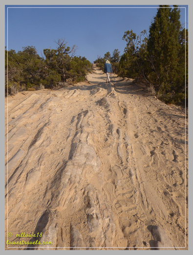
Moonshine Arch Trail
This was another winner. Hiking to an arch is always exciting, even one less spectacular than this one. Moonshine Arch is one of Vernal’s best kept secrets, and we’re very happy that our friends John and Pam had done this hike in the past and recommended it.
It took us a couple of tries to find the trailhead, and we suggest using the map provided by the State Park – and the All Trails app if you have it.


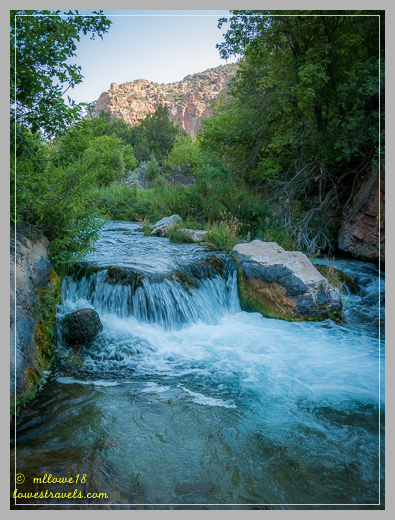
Jones Hole Trail
When our friend Hans noticed on Facebook that we were in Vernal, he immediately suggested an excellent hike – but it was 40 miles to the trailhead. Hans and Lisa know a good hike when they do one, so after a bit of groaning by Steve we were on our way. Wow, they weren’t kidding – just the drive to the trailhead at Jones Hole National Fish Hatchery was worth the trip!


The trail is in a remote and scenic part of Dinosaur National Monument that runs from Jones Hole National Fish Hatchery to the Green River. It was an easy 8-mile round trip hike, changing only about 200′ in elevation. The walls of the canyon towered almost 2,000′ overhead, giving us shade during much of our trek.


This is an awesome trail that offers so much – a scenic canyon, Fremont Indian archeological sites, a spur trail to a small waterfall, and a Bighorn Sheep sighting if you’re lucky – all while meandering along babbling Jones Creek until it joins with the Green River. We loved it!


Petroglyphs (rock art) and Pictographs suggest that Fremont Indians hunted game here some 800 to 1200 years ago:


Eagle Ridge Trail
On our final day at Steinaker State Park, we accessed the park’s Eagle Ridge Trail from the group camping area. It followed the ridge and gave us great views all around, including a glimpse of Moonshine Arch, Hogback Ridge, Betsy in the campground, and almost empty Steinaker Reservoir. It’s expected that the reservoir will be re-filled in Fall of 2019 after planned dam modifications are completed.


That wraps up our one-week stay at Steinaker State Park. It was hot and smoky, but we felt we had explored much more of the place where the Dinosaurs once roamed.

The hikes to Moonstone Arch and along Jones Creek look fabulous! Such a bummer that you’ve been affected by smoke even in Utah, but I’m glad it wasn’t bad enough to stop you from getting out and adventuring.
Good luck with your blog facelift—I know how much work it is. I’m looking forward to seeing your new look. 🙂
Disgusting air quality but what neat formations. I especially love the massive, curved cliff faces!
On another note, we’ll be heading to Fruita for a weekend in early October, so if you guys are still around maybe we can coordinate a quick hike or something 🙂
More great hikes for us to copy in the future, hopefully with less smoke. (ugh!) It has been terrible here in the Seattle area, too, for weeks now. Glad to see you were still able to get out and about despite it. This time, I disagree with Steve on the calorie counter. :)-
Looking forward to seeing the “new” blog when it recovers from the cosmetic surgery!
Sure looks like a great time back at Vernal! We, too, had to hike the mile up to the arch. It would take a specially fitted Jeep to drive closer. There were huge, deep washed out areas right after the main parking area. We parked and walked rather than fight the lose of road. Love the Hike Hans suggested. It’s always fun to have the sounds of the water along. Looking forward to your new facelift!
We were supposed to explore this area this summer (right before we saw you at Henrys Lake), but canceled the plans because of the relentless heat. I give you guys a lot of credit for hiking in those kinds of conditions. Even in the mornings, I can imagine how tough it must have been. You all never give in!! Anyway, thanks for the tour. When we do visit (some nice cool fall day, perhaps?) we’ll be sure to check these spots out.
Best wishes on the blog redesign. Having done it ourselves, we can say with absolute certainty:, it’s so much fun, but SUCH a nightmare! Hahaha! Good luck!!
🙂
Following blogs is certainly the best way to find about amazing places to visit that I have never heard of! This place & gorgeous hikes will be on our radar next fall!
Looks like you two had as much fun in Vernal as we did! Such a great area to explore.
Vernal is still on the list for us MonaLiza…many thanks for beautiful photos and so many awesome hikes to do!
What a great picture of Betsy overlooking that gorgeous view. I’d say Vernal has a great sense of humor with their pink dinosaur mascot. It’s really hard to imagine the rocky Utah as a sea with dinosaurs. We’ve had 95 for the past two days and oh my I’d hate it if it went on and on. Don’t know how you can hike in those temps and with smoke. And you have on long sleeves too. Those tracks are incredible. I’m just so amazed that they are still there after so much time and that water then and now hasn’t destroyed them. That nugget sandstone is huge. Steve really makes that clear in the picture. Also a great picture of you showing just how steep your climb was. Really love the shadow picture. That is great! What a variety of hikes you did. You know I love that gorgeous water and the waterfall. Not to mention the Big Horns. What fun you had! Thanks so much for putting them on my radar.