Like most attractions in a national park, the best way to experience diverse landscapes is to hike among them. The weather wasn’t forecast to be good during the second half of our stay here, so we wanted to cover as much ground as possible right away. A variety of trails gave us plenty of options to choose from, and this post will be a bit lengthy and loaded with pictures from our adventures.
A long loop trail
Our first day of hiking was full indeed. Starting with the Cohab Canyon Trail, we began our trek at the park’s campground and added the Frying Pan, Cassidy Arch and Grand Wash trails. We finally completed the 12.2-mile loop by returning to our car from the far end of the Cohab Canyon Trail.


We transitioned first onto the Frying Pan Trail, which increased in elevation and offered stunning views in every direction. We were feeling the burn by the time we moved onto the Cassidy Arch Trail, where we rested after hiking to the amazing arch where a bunch of noisy tourists were hanging out.


Next we connected to the Grand Wash Trail and walked through a wonderful sculpted canyon with a narrows section and unique melded rock formations. Since the park doesn’t offer a shuttle service, we had to walk 2.6 miles along Hwy 24 to the far end of the Cohab Trail to hike back to our car. We were worn out!


Hickman Bridge Trail
The next day we took it easy and hiked a popular short trail near the visitor center. It was the Hickman Bridge Trail, only 2 miles roundtrip but strenuous enough that we saw several people turning around halfway through. Continuing along we came across a small “double bridge” formation. This minor cavity was once a pothole known to arch hunters as Nels Johnson Bridge, named for the first permanent Euro-American settler in the area back in 1880.


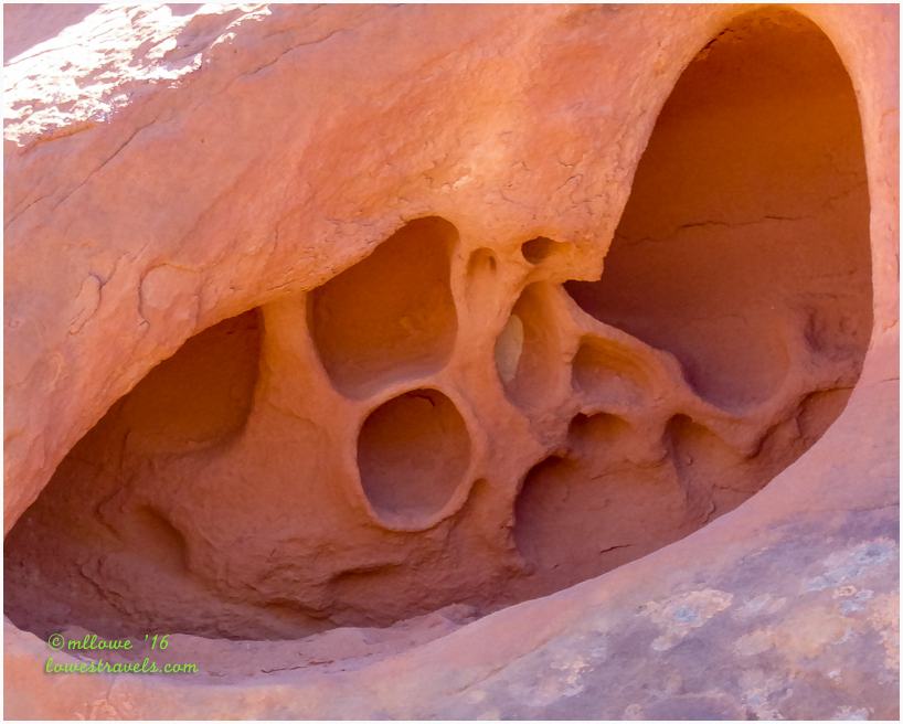
It was what I saw looking down, rather than up, that grabbed my attention to take a snapshot of these wild beauties. I can never say no when they’re so pretty.


Before heading home we stopped at a sign pointing to some petroglyphs. From 600 to 1,300 years ago, native people of the Fremont Culture made their home at Capitol Reef. Petroglyphs were carved here to detail their daily lives – or so we think. Only the artists knew the true meaning of these drawings.

Petroglyphs and pictographs at Capitol Reef are more recent examples of works of the Hopi and Pueblo of Zuni tribes from this area.

Fremont Gorge Overlook Trail
We had read that one of the least traveled but best hikes in the area was the Fremont Gorge Overlook Trail. On another beautiful morning we headed out early to investigate and were impressed by this one. It included an 1,100’ elevation gain over a 2.3-mile hike to the top of an overlook that revealed amazing views of the Fremont Gorge.

After an initial 400’ climb at the beginning, we walked just over a mile across a volcanic boulder-strewn field to the next section, a killer 700’ hike to the overlook.


The views all around were awesome!


We took a couple of short hikes to finish this day, a 1-mile roundtrip on the Sunset Point Trail and a short .2-mile jaunt on the Goosenecks Trail. They were both accessible from a parking lot at the end of a gravel road that started at Panoramic Point. We felt the strong winds as we walked here and saw its handiwork on the unusual rocks.

The goosenecks of Sulphur Creek were a challenge to photograph on an overcast day. See the streaming water 800′ below? That’s Sulphur Creek, a tributary to the Colorado River.

From the aptly named Panorama Point, to the Sunset Point to the Goosenecks, the views were fabulous. Actually, everywhere we hiked within this park was stunning.

We did so much hiking on this stop that I broke up our treks into two parts. So there’s more to come!
Comments
6 responses to “Hitting the Trails at Capitol Reef NP – Part 1”
There are so many people we follow exploring Utah this Spring. Every photo is better than the previous one.
We have never explored Capitol Reef. Just an amazing place. I love art that wind and rain designs on the rocks.
What a cute photo of you two on the edge. Print and frame that one! Thanks for the gorgeous tour. So glad you are having perfect weather to enjoy your adventure.
Wow 12.2 miles. I am such a slow hiker looking at everything it might take me two days to do that plan. But what wonderful pictures of this magnificent landscape. And I know it was even more beautiful in person. I just love Capitol Reef and think we have done most of these trails but in different pieces. I like the way you put them together. Looks like you must be having great weather and nice temps.
Beautiful… I need to hit some of those trails.
Great round up of hikes in Capitol Reef! We’ve done a few of them, but not all — we definitely need to go back. The views are spectacular, and you did a wonderful job of capturing the magnificence of the landscape.
This is the most beautiful park. I never tire of all the magnificent colors and formations. So good to back and revisit:) Gorgeous photos, MonaLiza and Steve:)
Thanks for the tips on hiking in Capitol Reef, think we need to go back and do a few more. Looks like we got some of the same pictures.