While writing about yet another week of exploring yet another amazing place, it dawned on me that we’ve been in southern Utah for over eight weeks! We continue to immerse ourselves in the natural and majestic surroundings, and this post spotlights some of the fascinating features of south-central Utah – mostly the area along Scenic Byway 12.
Red Canyon in the Dixie National Forest
Traveling east on Scenic 12, the first panorama that grabbed our attention was Red Canyon in Dixie National Forest. The unique vermillion-colored rock contrasted with green pines and we knew we’d have to investigate further. Although this place is lesser-known than its more popular and crowded neighbor, Bryce Canyon, it certainly has its own unique geologic treasures.


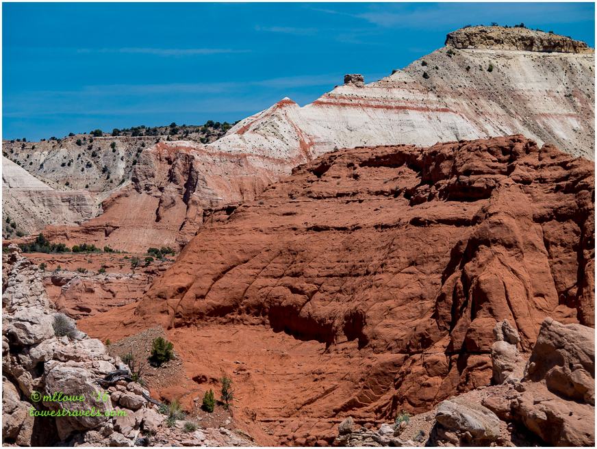
Kodachrome Basin State Park
Seven miles off Scenic Byway 12 is picture-perfect Kodachrome Basin State Park. In 1949 the National Geographic Society – with the consent of the Kodak Film Corporation – named the park Kodachrome. We were curious why it was named as such, and we figured it out while hiking all of its 14 miles of trails.

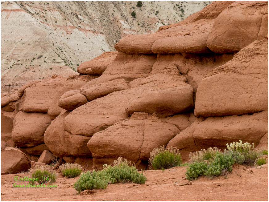
It turns out the setting of red-tinged sedimentary spires (or chimneys), multi-colored rocks of yellow, pink, white and brown contrasting against a blue sky and green trees prompted the appropriate name.
On this sunny day with clouds developing overhead my camera was in overdrive!


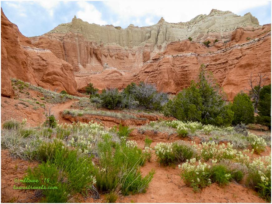
The park holds around 70 phallic-type formations, which are actually monolithic spires protruding from the sandstone rocks or jutting up from the valley floor. Some stand as sentinels at the park’s entrance.


Steve was walking along and jumped a foot in the air when he almost stepped on a small rattlesnake. He’d been exposed to many of them while growing up in California, but was excited to have me see one in the wild. I saw another snake up the trail a few minutes later, but it wasn’t poisonous so Steve didn’t care about that one 🙂


What do you think? Did the National Geographic Society name this place appropriately?
Grand Staircase-Escalante National Monument (GSENM)
This year GSENM celebrates its 20th birthday. In 1996 President Clinton designated this vast unspoiled and untamed 1.9 million acres of sandstone canyons, cliffs and plateaus as a national monument. It’s named for the Escalante River Canyons and for the Grand Staircase which is explained below:

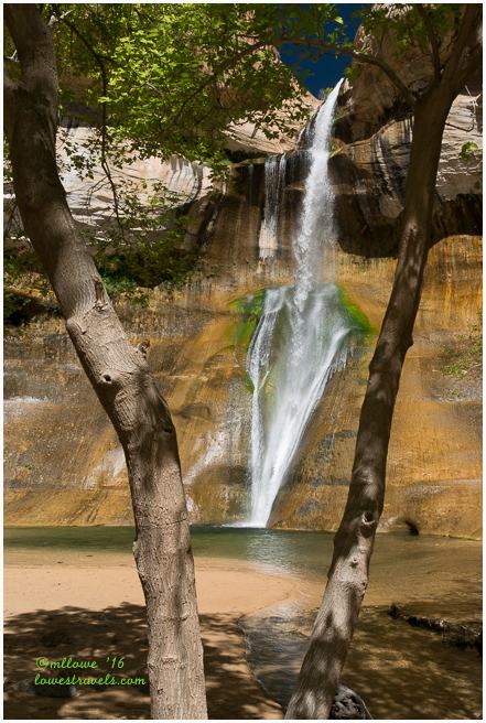
 One of the most well-known and unique features in this monument is the 130′ high Lower Calf Creek Falls. It was named for its use as a natural pen for calves back in the late 1800’s, and it provided a nice 3-mile hike to the falls on this beautiful day.


After our hike, we stopped for lunch at Hell’s Backbone Grill in Boulder, right along Hwy 12. It’s known for its organic food offerings grown onsite. I had the Spicy Cowgirl Meatloaf while Steve enjoyed his Backbone BLT, Yum.


Next we drove the Burr Trail Road, which led us deep into the monument. We drove up to the junction of Upper Muley Twist, about 33 miles from Boulder. It was one of the many striking backroads that we have driven recently.


In the 1930’s the Civilian Conservation Corps spent five years building Lower Boulder Road, now part of Highway 12.


We were happy to meet up with our friends Dave and Faye of The Wandering Camels at the Cannonville KOA (Steve’s campground review here). We hadn’t seen them since last December in Arizona. Faye suggested we hike the Lick Wash Trail, a fairly remote spot in Grand Staircase/Escalante National Monument.
We all took their big truck down the fairly rough Skutumpah Road to begin our hike on a beautiful morning.


The first 1.5 miles of this hike was beautiful, and then Steve suggested we head back to take on the Bull Valley Gorge, a slot canyon hike we had passed on our way here. He’d read about a 1954 pickup truck that had slipped into the canyon, killing three men. Their bodies had been removed, but the truck remained wedged in the canyon with large rocks and trees sitting over it.

On our way into the canyon we met a woman leaving who asked if we were experienced canyoneers, and she seemed concerned when we said, “What’s that?”. It got our attention, and we weren’t sure if we’d be able to complete this hike. But since Dave is in great shape, we figured he could toss us up or down any troublesome obstacles, and on we went.
After about a half mile of navigating several drops and obstacles we came to a difficult rope that went down about 10′. The girls said “No thanks”, but the guys said, “Heck yes!”


Steve and Dave continued on while Faye and I stayed behind. About a half hour later they came back like a couple of boys who had just enjoyed a great adventure. They had walked all the way to where the truck was lodged in the canyon, and they’d taken a bunch of pictures showing the beauty along their route.


After this journey we were all thrilled to consider ourselves canyoneers!
A glimpse of Bryce Canyon
The following day’s forecast was for rain and snow at higher elevations. Our plan to hike the backdoor to Bryce Canyon via the town of Tropic was redirected to driving the scenic road through Bryce Canyon National Park. We stopped at every overlook, and the rain started just as we were wrapping up the last one – perfect! For Steve and I, this was our first glimpse of Bryce Canyon and we were totally blown away. But we’ll save that story for the next post…

Comments
11 responses to “A week of rugged and colorful scenery – Cannonville, UT”
Well you’ve done it again, taken me to two places Kodachrome and Grand Staircase- Escalante, that I so want to go to. Your pictures are fabulous. Really love the 3 picture panorama and the one following it as well as the waterfall and your canoneering pictures. Great zoom on the rattler too. Lucky Faye and Dave to be on that hike with you guys. Blown away is definitely the right description for a first look at Bryce. One of my top favorite parks.
Utah rocks…that’s for sure! Absolutely amazing everywhere you go! Beautiful pictures as always MonaLiza…
Oh my! Amazing view. Please take me with you. Just give me a thumb’s up and I’ll start the adoption papers. Bwahahaha 😀
Utah has so many amazing treasures, and it looks like you guys are doing a spectacular job of finding them! We’ve seen a lot in our many years of traveling in the southwest, but you’re finding some things we’ve never seen—like that slot canyon. Glad you took that hike for us, because I don’t think we’ll be doing that one. 🙂
Now you can understand why our first visit to southern utah took three months, and we continue to return each year for three months. We still have so much left to see. The area is just so gorgeous and full of amazing adventures. It was such fun to revisit them again through your eyes:) I sure do miss Utah. Super job capturing the snakes…two in one day!
Two snakes in one day…cool! Isn’t this possibly the most amazing landscape in the entire country, maybe even the world?!?!?!
That snake tongue was crazy and lunch looked great. That was some amazing hiking.
That’s amazing about that truck, Mona Liza. The rubber is still on the wheels!
Absolutely fantastic! I’m getting a bit envious of you guys! Thanks for the glorious tour! 🙂
I totally agree with Steve’s review of the park, next time there will be advance planning so we can get into Kodachrome Basin SP. We really enjoyed the week with you two and our first experience as canyoneers. Great pictures of our hikes and the wonderful area, see you in Sept.
Love those slot canyons with rope climbs. Great shot of the snake too!