
By the second week of our stay we avoided going into Zion National Park, for the spring break crowd with its associated traffic was getting tiresome. We found some trails outside the park and just a few miles from our site at Zion River Resort in Virgin. They didn’t have the spectacular scenery that we’d gotten used to, but they held plenty of beauty.
Confluence Trail
Confluence Park is a 344-acre natural park that is uniquely located within the city boundaries of both Hurricane and LaVerkin, Utah. It’s tucked down in the bottom of a rocky gorge where Ash Creek and La Verkin Creek meet the Virgin River. Several trails criss-cross the park and we leisurely followed some of them. It was an easy walk and we enjoyed it for the natural beauty and almost total quiet, except for a few chirping birds.


Not typically seen on our hikes, a rope swing hung from a tree next to the river. I had to give it a try, but decided not to actually let go and plunge into the cold water.

La Verkin Overlook Trail
Just three miles west of our campground on Hwy 9 near the town of La Verkin, we discovered a 1.5-mile gravel-and-dirt road that lead to La Verkin Overlook. The first time we drove here was to check out the 360-degree view of the richly colored valley and mountains ranging from Zion to the Pine Valley Mountains. We noticed a trailhead right off the parking lot and vowed to come back to check it out, time permitting.
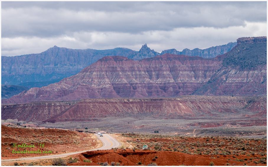
Well, we did make it back and guessed the La Verkin Trail was probably a good workout hike for the locals, rather than a challenging destination hike. No matter, we were going to give it a shot!
The trail was all downhill at the beginning and ran parallel to stunning cliffs with steep drop-offs to the left and gentle sloping hills to a neighborhood in the distance to the right. Although it was rather cold that morning, I enjoyed this hike because of the many wildflowers in bloom.
We also had good views down into an impressive section of the gorge that’s been cut by the Virgin River as it flows relentlessly through the towns below:


According to Wikipedia, theories about the origin of La Verkin’s name suggest it may be a corruption of the Spanish term la virgen, after the nearby Virgin River, or possibly an error in translation of the term “beaver skin.”

We stopped at the foot of the bridge and could go no further, as the trail ended at a power plant that was gated and fenced.

On our way back, these vibrant yellow, orange and red wildflowers caught my eye:


This was a fairly short but moderate hike, and we found it to be a good diversion from the big-time hiking we had done during the past week.
We were faced with colored and layered mountains as we headed back out the dirt road toward Hwy 9.

Northgate Peaks Trail
One day we drove the Kolob Terrace Road to pick up the Northgate Peaks Trail. This trek weaved through tall Ponderosa Pine groves throughout its length. The 4-mile round trip trail ended on a craggy knob of volcanic rock, with views of slickrock, sandstone towers, and a big cloudy sky overhead. A brisk wind prevailed on the day we tackled it.
The morning greeters kept an eye on us as we passed:


Along the way we encountered an area that had some weird sand trails. Steve thought they may have been created by moles, but they look different. Anybody know?


With the storm clouds threatening above, we hustled back to the car. The unique scenery with Stellar Jays, Northern Flickers and Mountain Bluebirds made this an enjoyable hike, and it turned out to really be for the birds 🙂

Eagle Crags Trail
Driving back and forth to Zion NP numerous times, we couldn’t help but noticed a jagged rock formation near Hwy 9 at Rockville. We learned it was called Eagle Crags, a sandstone formation that topped out at 6,350′ and included a hiking trail that lead to its base and then up into the rocky spires.

Keeping “crowd control” in mind, we bundled up and headed out early one morning. A sandy and rocky road just south of Rockville challenged our poor CRV to the max as we drove up through some private roads to the trailhead on BLM land.
We began following the trail, which gradually climbed across a juniper-covered ridge and toward the craggy towers rising to the south:


As usual, I couldn’t help myself and stopped every time I saw colors along the trail. No matter how large or small, it was springtime after all and the wildflowers were showing off their colors:


We hiked just beyond the base of the mountain to where much more strenuous rock climbing would have been required to continue. We had no intention of trying for the top of these jagged rocks, and were happy to just get close to them and stop for a nice view as we enjoyed lunch.


That wraps up our 2-week hiking bonanza in and around awe-inspiring Zion National Park. It’s definitely a one-of-a-kind place with countless hiking opportunities. We love this place and will definitely come back!
Comments
11 responses to “Final hikes beyond Zion National Park”
Fun hikes and beautiful scenery. Your Zion posts brought back fond memories of our visit there several years ago. Zion was my favorite of the Utah national parks.
We haven’t visited Zion …yet! But when we do, I will definitely be referring back to you stay there. Beautiful pictures as always…
There are so many trails in and around Zion, not to mention Snow Canyon over near St. George. Now you can see why we hiked 27 of the 30 days were there:) Great photos! I can’t believe all the flowers in that area back then. We still don’t have that many out a month later here.
I always thought those mounds were from moles as well, but I’m no expert. Also, beautiful photos, I’ll have to check out some of these hikes next time I’m in the Zion area!
Sorry to hear the spring breakers are everywhere. Do we have to hibernate in March and April to avoid the crowds? Looks like you’ve found the answer. Hardly looks like an old lady on that swing. Great pictures!! I’d have been right there with you. Great pictures of the flowering cacti. I’ve been hanging around the long leaf pines and loving it but the ponderosas are my absolute favorite. Hope you gave them a big sniff for me. What a scent! Love the shot of Steve among the pines. Your pictures of the landscape are fantastic. Love the storm shots. That final picture of the two of you should be framed. Really great! Sorry to see you leave Zion. I sure have enjoyed your posts.
Thank you for posting all your Utah hikes! We’re rolling through in May/June, and I will refer back to these pages for tips.
So beautiful, Mona Liza. You found some great out-of-the-way places that we’ll enjoy exploring on our next trip to Zion. Northgate Peaks Trail and Eagle Crags Trail look especially intriguing. We’re all for avoiding the crowds, too — not fun to hike in a pack. Unless it’s a pack of our friends. :-))
Hope to spend a day at least in Zion next month, we’ll be staying in Kanab and we plan to do a day trip there. You’ve given me a lot to think about in regards to hikes.
Enjoying your blog. Wonderful pictures
Wonderful pictures once again MonaLiza.
Beautiful photos as usual! You two are so lucky to have found each other, and someday you’ll look back on these beautiful photos and marvel at all you two accomplished 🙂