From the Tucson area we moved west, stopping at Casa Grande, AZ. After arriving there, we did our usual investigation for places with good hiking. We didn’t find anything in the immediate area, but we discovered that beautiful Picacho Peak, which we had admired from I-10 west of Tucson, is located within a state park about 33 miles from Casa Grande.
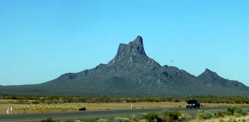
This striking peak has been a navigational point for ground and air travelers for decades. It rises 1500 feet from the desert floor and has several hiking trails of various difficulties. At first, we weren’t sure we would try for the summit, as it was rated “difficult” and we are more into “moderate.” It is recommended that hikers take gloves to assist with “holding onto the cables”. Oh, that sounds interesting!


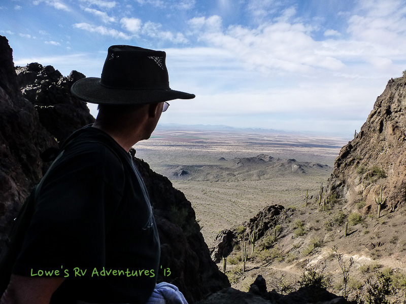
We parked at the Sunset Vista trailhead on the west end of the mountain and decided to check out the first couple of miles. What a fantastic trek it was! This trail was an easy walk with beautiful scenery on the south side of the mountain which got us warmed up for an attempt on the summit. This is now one of Steve’s favorite hikes, with sweeping views of the mountain and 30+ miles of valleys all around. Gorgeous!

After the first 2 miles, the trail became more difficult, and soon we were faced with either climbing steep rock faces using the steel cables, or turning onto the Hunter Trail to descend on the north side of the mountain. We decided to give the cables a try and guage ourselves (me primarily). It went OK, and as we continued along the climb got steeper with some narrow ledges actually fenced in to prevent folks from plummeting down several hundred feet. We trudged on slowly and carefully until we reached the top.


After two and a half hours of tough climbing we were there. We made it – whew! We were richly rewarded with a sublime 360-degree view of the Sonoran Desert. We took a break, soaked in the view and grabbed some lunch to renew our energy.


After lunch we descended 1.5 miles via the strenuous Hunter Trail to its trailhead at a parking lot. Since we had parked at the other end of the mountain, we needed to walk an additional 2 miles back to our car. It was a long 7-mile day of walking and climbing, but we were surely glad we did it.


As we soaked our sore muscles in the spa (luckily our RV park had one), we were happy to have accomplished this challenging climb, and we’re looking forward to the next one!
Comments
15 responses to “Picacho Peak kicked our butts!”
While you are still in southeast Yuma, sneak over to the Wickenberg area and hike Vulture Peak–great views. That was one scary looking hike you just took! YIKES
Oh, we passed by Wickenberg early December but did not know about this hike. Next time around we will check it out. Thanks
Congratulations you two. That is one tough hike!
Thanks, as they say do it, while knees are not creaking yet 🙂
Absolutely. I commend you both as that is one scary hike. 🙂
very impressive effort and great views as a reward.
Thank you, it was indeed a great view up there.
On our trip in 2011 I wanted to visit the Ostrich Farm in Picacho that was there, but sadly it was closed the days we were driving through. Looked interested, also had monster truck ride that the kids would have loved. Love the country you are driving through right now and enjoy your blog!
We glanced at it but it seems there were no parked cars so we did not go. Glad you are enjoying our travels.
Way to go you two! Now whenever you drive past Picacho Peak you will remember your triumph!
Exactly, we would even waved at on our way vack east.
Way to go!!! Amazing hike with beautiful scenery….doesn’t get much better, does it?
Stop by here on your way to CSP, there is a state park here at the base of the mountain.
What a great adventurer – Congratulations on making the summit.
Thank you. We try while we still can.