Leaving Flagstaff at 7,000′ elevation, we knew Betsy would get a good workout on the way to our next destination at Jacob Lake. Following US89, we climbed steadily and then continued onto US89A for a drop to 4,000′. Finally, we climbed back up onto Kaibab Plateau and followed the curvy road to Jacob Lake, at 7,921′. Lots of ups and downs, but what scenery along the way! We were so captivated by the gorgeous views at Marble Canyon that we vowed to go back with the car after getting settled in.

During the drive we received alerts of thunderstorms ahead, and although we saw some dark clouds on the horizon we made it unscathed – yay!

The scenery kept getting better and better as we crossed the Colorado River on the Navajo Bridge at Marble Canyon, and soon the Vermillion Cliffs hugged us all the way to the foot of Kaibab Plateau. We just had to pull over to take in the view and get a pic of Betsy:


When we checked in at Kaibab Camper Village, they mentioned how lucky we were to miss the hail storm that had just passed through. There was so much on the ground that we thought it was patches of snow!

For some reason I had thought Jacob Lake was a “must see” body of water. Imagine my disappointment upon seeing basically a small pond next to the campground! But I learned that it was once an important source of water when there was virtually no freestanding water on the Ponderosa-pine covered Kaibab Plateau.

 We had only one full day to explore, so we set out super-early to visit two incredible canyons, the North Rim of the Grand Canyon and Marble Canyon.
We took the car to the North Rim via Hwy 67. It’s normally only open June-October, maybe shorter depending on accumulated snow at its 8,238′ elevation. Getting only about 10% of the visitors that the South Rim does, we had lots of elbow room to drink in the views and not be jostled by crowds.


The South Rim has better views of some cliffs and the Colorado River, but the North Rim definitely holds its own and has a more laid-back atmosphere that we really enjoyed. Check it out if you can!
After walking around the immediate area and snapping many photos we retraced our drive on Hwy 67 and headed east on US89A to Marble Canyon. With no impending storms to worry about this time, our drive was enjoyable and we had plenty of opportunities to feast our eyes on the beauty:


We stopped for a look at some quirky stone structures along the highway near Marble Canyon. There were no plaques describing them so we just looked around. After some research I learned that these were not ancient dwellings, but structures actually built by a woman in the 1930’s.
The story goes: “Around 1927, Blanch Russell’s car broke down as she traveled through this area. Forced to camp overnight, she decided she liked the scenery so well that she bought the property and stayed. The stone buildings under these balanced rocks were built shortly after that in the 1930’s.”


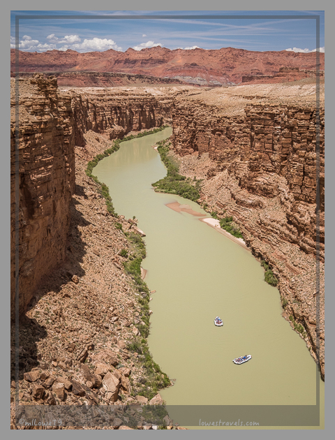
Marble Canyon is so called because of its colorful rocks and cliffs, stunning when the sun shines on them brightly. It’s an area along the Colorado River between Glen Canyon Dam in Page, AZ (here are my pics of our Glen Canyon Dam tour) and the confluence of the Little Colorado River. Along with Lees Ferry, Marble Canyon marks the beginning of the Grand Canyon at its most western point. And the best vantage point to see it is by walking along the historic Navajo bridge.

Before the bridge, people have to travel 800 miles around the canyon to reach the other side of the river. After its construction it made a direct route between Arizona and Utah and by opening day in Jan 1929 it was the highest steel arch bridge in the world!

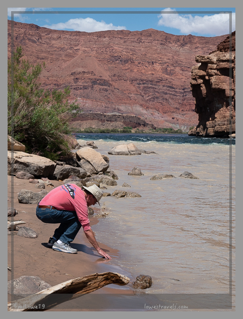
After walking across the bridge and enjoying breathtaking views of the river 467′ below, we drove down to the shoreline where the silty Paria River meets with the main channel:
Nearby was Lee’s Ferry, where all Grand Canyon river tours begin. The two rafts we had seen floating down the river began their journey right here. Watching them load the supplies gave Steve an idea – why don’t we do that? OK, dear, add it to the bucket list!


It was a long day of driving 182 miles to marvel at two incredible canyons, both carved by the Colorado River and absolutely incredible. Did I say incredible again? Anyhow, it was so worth the drive!


Wow! is right! great photos of amazing views, thank you for sharing 🙂
So pretty, MonaLiza! I found my eyes being drawn to those cliffs when driving along 89-A. It’s one of the most beautiful drives I’ve ever been on.
Driving highway 89A should be in everyone’s wish list! Too bad for us we did not see some condors even if we passed here three times!
I love your stuff, thank you!
Thumbs up to Steve for that sign pose.
TLG and I were going to hit the North Rim this fall, but plans changed. Now I’m sad looking at those views.
NO RUNNING AROUND WHILE DRIVING 😁
I think he is learning from you TBG!
Shhh don’t say that people in uniform might here you and stop Betsy 🙂
I’ve never visited either of those canyons…they’re on the list!
Definitely worth a visit, hope it makes to your list for next year.
Wow! Your energy always inspires me! Thanks for sharing these beautiful pictures :))
Thank you Carol, the scenery makes us giddy with joy!
Amazing photo’s. We love the Grand Canyon. Some day we want to do the float trip also. We just don’t know when we will fit it in.
I think you have better things to do with your new boat. The rafting can wait 🙂
Beautiful areas! While Jacob’s Lake was a bust, it did allow you to visit the North Rim. Looks like you had a beautiful day. Much better than our cloudy day with snow showers. Sometimes the miles are necessary to take in everything around you. Love the photo of Betsy with the Vermillion Cliffs.
We did luck out on the North Canyon, the reason we cut short our Flagstaff visit. Thankfully there was no snow storm like you had. I agree to see some beauty we need to drive farther 🙂
So glad you guys missed the hail storm!! That is something I never want to experience in our travels. Talk about devasting for a rig!
It has been years since we’ve been to the North Rim, but we remember it as being a wonderfully peaceful alternative to the South Rim. We saw condors while we were hiking there, which was cool! Your photos are beautiful and make me want to return. I’m betting that we’re going to be hearing that you’ve signed up for a rafting trip in the Grand Canyon in the future. :-))
I just wished I took a picture of the hail on the ground, for it did look like snow. But then it rained a few hours later. Too bad it was just a short visit for us and we did not see any condors while there.
After reading all about the rafting we are seriously thinking about it especially when I learned I don’t have to paddle 🙂
Incredible is the perfect word to describe the canyons! I enjoyed this post so much because it reminded me of our first big RV trip. The Grand Canyon North Rim was our first major destination in July, 2006 when we began our maiden RV journey from Georgia. We stopped at that same overlook at Vermillion Cliffs and stayed at the same campground and made the drive to the North Rim two days in a row. We arrived right after the 2006 fire and we could still smell the smoke as we passed by the burned area. Thanks for posting the pictures of the aspen. I’ve often wondered if the forest there had come back to life yet.
Looking forward to your Utah posts.
Wow, you made the North Rim your maiden visit all the way from Georgia! By then you must have said this RVng thing really is fun! Glad we could take you back and it looked like the regrowth of the Aspens is the only thing that has changed since your last visit. I bet at that time too in 2006 there were less people 🙂
What an incredible area, one we have yet to visit but every time we read a post about the area we want to drop everything and head that way!
It took us three tries and finally our route and and the earlier than usual opening of the North Rim made it happened. Definitely worth a visit.
Incredible indeed! I don’t know if I am more impressed with all that beauty or your energy to enjoy both canyons in one day! You guys are awesome!
Thank you Gay, we have to rearrange our reservations when we learned the North Rim opened weeks earlier than usual. It was a long day but we definitely enjoyed it !
We had wanted to visit the north rim when we were relatively close by, but it was closed with snow at the time. Your photos inspire me to prioritize getting there. I’ll take just ‘slightly” less impressive views with far fewer tourists any day of the week. Those Adirondack chairs overlooking the canyon look mighty inviting! Love your photos of Marble Canyon too, and those spectacular bridges! We’d love to do one of those rafting trips someday as well.
It was snow too that stopped us twice and was happy our timing was perfect this year even if it was just a short visit. After learning that the rafting trips is motorized and food and lodging taken cared of, we are seriously thinking about it.
The crowds here are nothing compared to the hordes of people at the south rim.
While you always look mighty cute in your sign-posing photos, I have to give props to Steve for his creativity.
As TBG said, we nixed our plans for the North Rim, but it will undoubtedly be added in again at some point. Your photos only serve to make us that much more determined to see it. Is there any hiking to be done at/near the North Rim? The Vermilion Cliffs are simply jaw-dropping.
Rafting?! So adventurously ambitious! Can’t wait to hear (and see) you’ve done it.
Stay cool, my friends! 😀
Ha ha ha, Steve is my reluctant model 🙂
Yes, there are trails there and one, the North Kaibab Trail descends to the Colorado River and the other to the Roaring Springs. We saw two campgrounds just outside and closer to the North Rim. And because the NR opens only a few months in a year, it does require some planning.
Thanks for taking me back to some of our favorite areas.