This is the second in our 3-part series about California’s rocks that we explored last January. The first one is here. 
Usually when we visit a state park our expectations are a bit lower than when visiting a national park. Then along comes a small state park tucked away in the arid Mojave desert that surprised us with absolutely stunning landscape.
Enter Red Rock Canyon State Park, one of California’s best kept secrets, located 120 miles north of Los Angeles. It’s situated in the southernmost foothills of the Sierra Nevada range, just west of CA Hwy 14, between Mojave and US 395 which runs through the middle of the park. We visited in January when there was hardly anyone else around, which is always a good thing.

Imposing cliffs composed of otherworldly looking red rocks created the scene as we approached the park on Hwy 14. For a moment it felt like we were entering southern Utah, for the buttes of vivid color and layered rock formations were similar. But these are California’s colored rocks so dramatic that it beckoned us to explore further.

As with our last stop, we had only one dry day to explore as the winter storms were nipping at our heels. We followed three trails: Ricardo Camp South Loop, Hagen and Red Cliffs (just across Hwy 14). These treks gave us different perspectives and views of the area badlands, and we loved the exposed angled and layered strata that spanned both sides of the highway in the Mojave Desert.


Hagen Canyon was named by a German immigrant, Rudolp Hagen, who acquired the land and then built a small outpost with a diner, bar and post office. He is attributed with starting the area tourist movement by operating Red Rock Canyon as his own private park, offering maps of rock formations, most of which he named.
After his passing the land transferred to his family before becoming a State Recreation Area in 1969, followed by an elevation to state park in 1982.
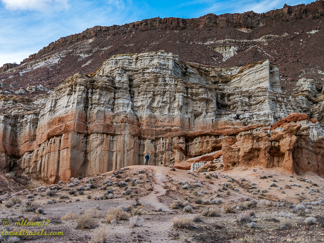
We followed the Hagen Trail to see the rock formations Mr. Hagen had named. I even named one myself!


Next we crossed over Hwy 14 to explore the Red Cliffs on the east side. We know from past explorations that the bright red coloration is due to oxidation (rusting) of high iron content rock in some of the sedimentary layers.


The park can be explored in a day, but you can definitely spend more time wandering off and immersing yourself in the geological wonders of the area. Hans and Lisa alerted us to this hidden gem, and we’re very glad we altered our route slightly to see these remarkable rocks of California for ourselves.

If you find yourself traveling on Highway 14 near Mojave, be sure to pull over and explore this place. It’s definitely worth a look!

I agree, this was a surprisingly wonderful find! You hiked some trails we did not and saw some really wonderful features we missed. I guess that means a return trip is in order!
I did a Google aerial of this…wow! Having never been there, I widened my view. I also saw some interesting things around Mojave: a huge wind farm, the Hunduai test track and a plethora of 747’s parked at the airport. Can’t wait to get out that way. 🙂
The map I posted on the first series has the actual route we took from west to east. And when you follow that on the reverse you will pass by the wind farm in Mojave.
Beautiful! We love exploring parks during their off season when you have the place to yourselves. You might have to put up with a little chillier temperatures but it is totally worth it!
Another wonderful stop full of awesome rocks. Magnificent colors and shapes!
The Google aerial is gorgeous, but I must say that your photos give Google a run for its money. Fabulous job!
Glad you listened to Lisa and Hans and didn’t miss this beauty. I am sure we won’t ever get there so thanks for a super job of taking us along for the ride.
I love finding unexpected treasures in our travels! Thanks so much for the beautiful photos—we’ll put this on our list for our many travels through California. You came up with the perfect name for that rock formation—it looks just like a giant lizard!
This is a park I need to see! I love those gorgeous formation and the colors are spectacular!! Looks like a perfect time of year to visit without the crowds. Cold and wind are better than people:) So glad you shared!! Beautiful photos! Love the one of you two:)
Who knew rocks could be so colorful and pretty??? Great photos!
Awsome landscapes!
Wow I had no idea there was landscape like that just north of LA. Your pictures of the views are exceptional. How wonderful that Hagen protected this area as did his family until it could become public property. I think your Resting Giant Lizard is a perfect name. Those red cliffs really do look so much like Utah. Really gorgeous pictures of them. Thanks for this post Mona Liza, you’ve put this park on my list. I’m with Mark, better cold and wind than all the people. What a wonderful picture of you two at the end.
You are giving me some great ideas for exploring California. Thanks MonaLiza!
I will b adding this to our list of places to visit! Beautiful photos! Thanks for sharing.