Autumn is a wonderful time of the year to visit Mount Rainier, perhaps only second to spring time when the wildflowers are blooming. At the time of our visit in early October, the meadows of Mazama Ridge had turned from colorful wildflowers to colorful autumn foliage of mountain huckleberry, vine maple and mountain ash. But I’m getting ahead of myself here.

This 14, 410′ volcanic peak was called Tacoma or Tahoma by generations of Northwest Native Americans. Then in 1792 it was renamed Mount Rainier after Admiral Peter Rainier by English explorer George Vancouver. Vancouver sighted the enormous mountain while exploring Puget Sound.
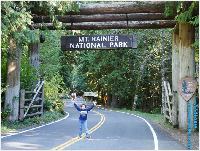
Mount Rainier is the natural wonder showcased in 365-square-mile Mount Rainier National Park, established in 1899 as the nation’s 4th national park. It’s the highest mountain in Washington and in the Cascade Range, and the most topographically prominent mountain in the contiguous United States. On clear days it can be seen from 100 miles away, and on our way there we caught our first glimpse from many miles away on I-82.


Our home base was Mounthaven RV Park (Steve’s review here), only 3 miles from the Nisqually Entrance on the southwest corner of the NP. Had it been summer we would have loved our site here, as Betsy was shielded by tall trees. But rain and fog enveloped the area during our stay, and being in the dark and cold all the time gave us a case of cabin fever.

Checking out the forecast for our one-week stay, we saw three days of mostly sunny weather and planned our hikes around them. To experience the maximum in scenic splendors we chose three trails: Rampart Ridge Loop, Lakes Loop and Skyline Trail via Panorama Point. They were all over five miles long and averaged 1,500′ of elevation gain. Of course, we started early in the morning and had to survive temps in the mid 30’s – brrrr! The lengths we’ll go to just to avoid crowds!

Rampart Ridge Loop
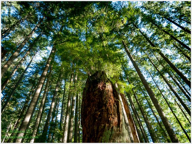
This steep loop took us deep into the forest, with lush vegetation and giant old growth trees along the ridge known as “The Ramparts.” It’s a remnant of an ancient lava flow which originated at the summit of Mount Rainier and retained it’s 1,000’+ height when glaciers around it melted.
Our trek was cold and damp due to the thick tree canopy that blocked out the sun most of the time. We took time to notice the various mosses and lichens clinging to the trees, and lots of fungi on the ground.


A variety of fungi were everywhere along the mossy carpeted forest floor:


This would be a great summer hike, as it’s covered by tall trees and is a good way to get some elevation gain. Beautiful forest views and a fantastic vista of Mount Rainier, all in just over five miles!

Lakes Trail Loop
Just over five miles around, this trail traverses through a myriad of delightful lakes at the base of Mount Rainier. Fog added a new dimension to the hike, making it mystical, moody and chilly. We were the only ones up there, and it was peaceful and easy to be one with nature as we trudged along the dreamy landscape.


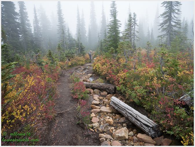


We were not disappointed, as the trail was a succession of gradual ups and downs passing through lakes, ponds, streams and waterfalls.


Writing this post, I had planned on putting all of our hikes together but soon realized the Skyline Trail needs its own post. It was the highlight of our stay, and we hiked it on a mostly clear day which made us discover exactly why this area is called Paradise. Stay tuned!


Beautiful photographs! Have a great time exploring nature.
Thank you Marcy.
This is a national park I’ve yet to visit. You were so fortunate to have a few sunny days. Beautiful photos…can’t wait to see what you discovered in Paradise!
If you are coming back to WA someday, there are so many trails in and outside the park to tackle. And Mt Rainier is such a beauty.
Outstanding photos! Beautiful landscape! Thank you for sharing! 🙂
We loved our visit to Mt. Rainer in summer of 2012 and have wanted to return. Seems like we need to plan a fall visit! Your photos are gorgeous—from the tiny colorful fungi to the stunning waterfalls and forest illuminated with the brilliant colors of autumn. Your hiking in the clouds shots are magical!
Im sure your hike then was filled with blooming and colorful wildflowers. That, I would love to see one day.
These are just spectacular photographs of Mount Rainier from the road and the trail, of the glorious waterfalls and the beautiful mushrooms. Really Love the one of Steve on the trail facing Mount Rainier that’s professional quality as is the foggy shot of you on the edge. I think you are more dedicated than I though. Not sure I could get up and out in the 30’s. Well done!
Thank you Sherry, glad I picked the good pics to post, it was a challenge since I took so many 🙂
It seems most of our hikes this year were in cold and chilly areas and our summer was really really short. I give credit to Steve for rolling me out to bed on chilly mornings 🙂
Stunning photos and wonderful blog! Thank you so much for reminding me why I love Mt Rainier! I grew up in Washington and enjoyed wonderful views of “my” mountain and really miss seeing it everyday! Beautiful blog post!
Thank you Terri, You are so fortunate you can visit “your mountain” again and again. Mt Rainier stands elegantly up there!
MonaLiza, this is one of your most beautiful posts. What magnificent colors…wow! Just so much beauty in one place. Can’t wait to see it all with my own eyes:) Mt. Rainier in the distance is spectacular! And Christine Falls with the bridge “frame” is a Wow! The brilliant green forest trails are lovely. Thanks for sharing so many wonderful photos! I just smiled my way through:)
Thank you Pam. There are a lot of hikes in the area, so I think you need to return here perhaps in summer for the wildflowers or Sept for the fall colors.
Absolutely breathtaking! I couldn’t pick a favorite picture. Well, ok. The one on Faraway Rock was pretty cool. My kind of hike. You’re right. A little bit of everything. We’ll be sticking to OR/WA in 2018 and I’m looking forward to really getting to spend more time there!
I too had a hard time choosing which pics to choose!
Wow these photos are amazing! Great post and blog! I really enjoyed looking through your posts and can’t wait for more! As a fellow travel blogger it’s so fun for me to meet other people and see their adventures and travels!
Spectacular, beautiful, stunning!!! I have only been to Rainier for wildflower season but these fall photos are even more colorful than a meadow of flowers. Enjoy fall out there ML!
Oh how I love Mt Rainier NP. Your photos are amazing MonaLiza! I would love to go in the fall, although the wildflowers were spectacular when we were there. I am looking forward to your photos of the Skyline Trail hike, one of our favorites!