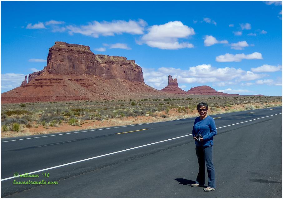
Excitement was in the air as we left Page, Arizona, heading toward our next destination at Bluff, Utah. Happily, our route along Hwy 163 took us through one of our bucket list “must-see” places, Monument Valley. It’s striking landscape is the most photographed area lying entirely within Navajo Indian Reservation territory along the Utah/Arizona border.
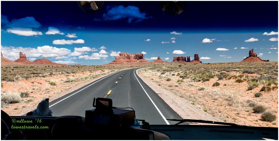
The Navajo name for the area is Tse Bii’ Ndzisgaii, meaning “valley of the rocks.” The sandstone buttes and mesas have been used as a backdrop for more than a dozen movies (including Forest Gump), and driving amongst them brought home the beauty of that backdrop for us.
The small town of Bluff (population 258 as of 2015) was our base camp for exploring ancient ruins and rock art. It’s in the center of the Four Corners region where ruins of Anasazi  communities have been found not only in Utah but also in Colorado, Arizona and New Mexico. The region is known as the Utah section of the Trail of Ancients, where Ancestral Puebloans (Anasazi) occupied from approximately A.D. 1 to A.D. 1300. Some of the remarkable remaining remnants left behind have easy access, but most require a drive and a hike, while still others exist in inaccessible back country areas.
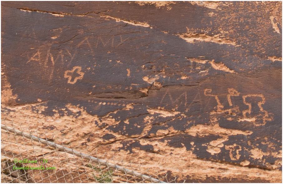
Sand Island Petroglyphs
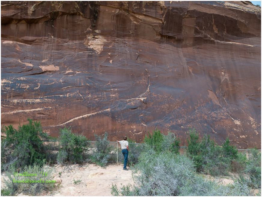
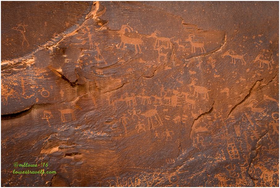
The easiest site to find here was the Sand Island Petroglyph Panel, located within the Bureau of Land Management (BLM) Sand Island Recreation Area just 3 miles south of Bluff. The petroglyph panel stretches more than a hundred yards and features hundreds of petroglyphs of every style.
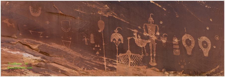
Wolfman Panel
The famous Wolfman Panel is about four miles west of Bluff along Butler Wash Road and just a mile from Utah 163. It’s a large, crisp and artistic group of etchings on the cliffs bordering the east side of Butler Wash. The panel has designs that include a mask, shields, human figures and the wolfman himself. Unfortunately, some of the artwork had been damaged by one or more morons shooting the rock with guns.

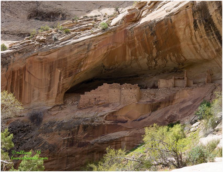
Monarch Cave Ruins
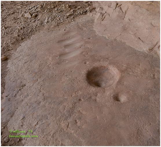
Getting to these ruins required a 7-mile drive down Butler Wash Road (a dirt road in good condition), then a 1-mile hike toward a large alcove surrounded by colorfully-streaked cliffs above a permanent pour-over pool. The site has one main ruin, several lesser structures and many petroglyphs colored yellow, green and white, in addition to the usual red. The main area had been closed off as it has been become unstable and dangerous.
Images on the rock that are painted on the surface with natural materials are called pictographs.


Grand Gulch Ruins
Once again our favorite hiking tipster Pam came through, pointing us to one of the ruins she and John (Oh The Places They Go) hiked called Junction Ruin. The trailhead is located west of Hwy 261 and south of Natural Bridges National Monument. The area is called Grand Gulch Primitive Area, and it’s a sprawling canyon system is home to a rich collection of American Indian rock art. Access requires a permit at Kane Gulch Ranger Station for day use and/or backpacking.
Initially our goal was to visit Junction Ruin as John and Pam had (click here for the details of their hike). It’s a large cliff dwelling built on three levels, and a fascinating complex consisting of storage units, habitation rooms, kivas and defensive structures.

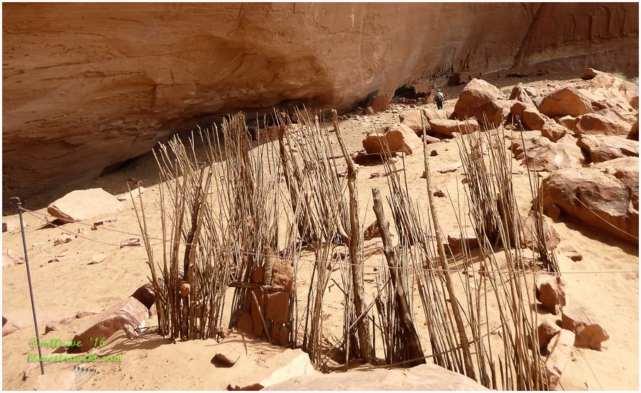
After perusing those ruins we met a group of backpackers who urged us to continue another 0.8 miles to see Turkey Pen Ruin. Onward we went to discover that these ruins encompassed a number of structures, along with some pictographs. Just like Junction Ruin, a metal box at the site contained descriptions of the scene and the structures it held.

The actual Turkey Pen is a jacal structure near the west end of the habitation area, and although its purpose is unknown, it didn’t look like it was used to hold turkeys.


We didn’t intend to hike 9.2 miles, but seeing both ruins made it more rewarding despite the uphill climb on our way out.
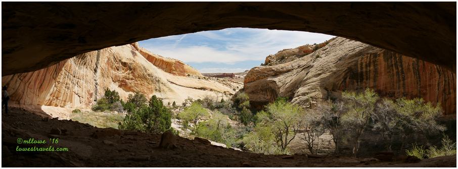
Natural Bridges National Monument
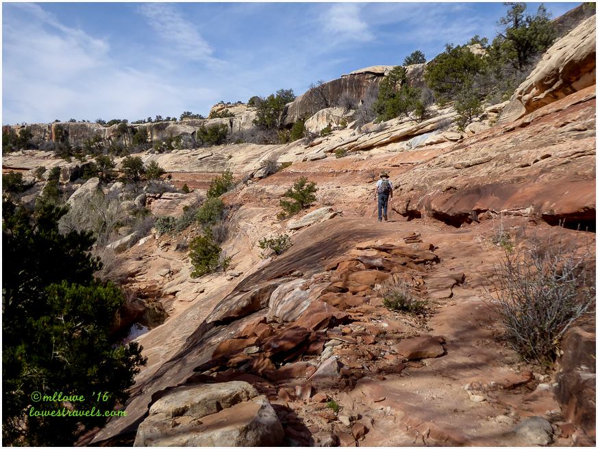
Tucked away in White Canyon, Natural Bridges National Monument shows off three natural stone bridges. The park ranger recommended we follow an 8.6-mile trail that connected all of them in a long loop hike. This trek really showed up-close how the power of water cut two deep canyons and formed three massive sandstone bridges.
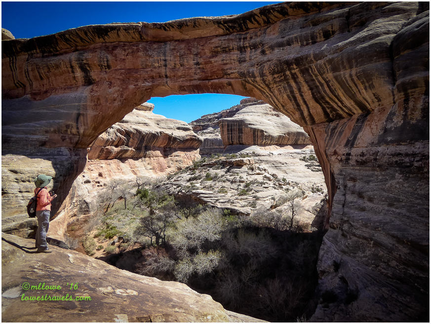
Descending into the canyon, we passed and crossed under the “Sipapu” “Kachina,” and “Owachomo” bridges. They were named after Native Americans who once lived in the area. Along the way we saw rock art panels and checked out Horsecollar Ruin.


We discovered the rock art panel when eagle-eyed Steve spied it high up on a wall not easily visible from the trail. It was near the end of our hike, which due to our extra wanderings had tallied up 11.6 miles on the GPS. It was a long and satisfying hike!
House on Fire Ruin
Our final stop that day was the House on Fire ruin. Consisting of about five rooms, its name comes from the patterns in the alcove’s red and white sandstone ceiling that look like flames shooting from the roof of the structures.
The best time to capture this effect is midday when the light from the opposite canyon bounces across to the ruin. Unfortunately it was 5:30pm by the time we arrived after our all-day “Bridges” hike, so conditions for my pictures were not ideal. This trek added another 1.5 miles to our total for the day, and we were exhausted but happy to see it while in the area.

Visiting ancient ruins gives us a glimpse into parts of Anasazi life, and the remnants tell tales of their daily toils. Images and art chiseled/painted on rock walls are impossible to decipher, but they must have had special meaning to the people who created them and the descendants who followed. Those first residents left us fascinating food for thought, and we can only imagine what their lives must have been like way back then.

Love that area and look forward to the day we can spend a few weeks in the area.
Thanks to Pam, we all were able to explore a very much overlooked part of Utah….shhhh, don’t tell anyone else!
I’ve spent plenty of time in southern Utah and yet I’ve never heard of these places (except for Natural Bridge). It’s amazing how much there is to see in that area! Beautiful photos!
We love Cedar Mesa — it’s one of our all-time favorite and relatively remote places for hiking. There’s so much to discover there! You did a great job of describing your hikes — those were some of our favorites, as well. If you ever head back to Cedar Mesa, we have a couple more favorites that we discovered last fall — Fallen Roof Ruins was as spectacular as House On Fire (with a great hike to it) and Petroglyph Panel was outstanding. I’m impressed that you guys tacked House On Fire onto a full day of hiking Natural Bridges! :-))
You two put in quite the mileage!
Love Bluff!! There are so many ruins yet to be investigated:)
Thanks for taking us along on your tour. I love those petroglyphs and rock formations.
I am convinced…Bluff needs to more than just an over night stay. Beautiful pictures and adventures.
Beautiful. Love to see the lesser known sites. Cliff dwellings always amaze me.
As a petroglyph lover I can’t thank you enough Mona Liza for this post. I am keeping it so we can visit every one of these wonderful spots. Your pictures are outstanding. Love the ruins and the drawings of the Ancients. So glad to see that there doesn’t appear to be much vandalism to them. What a magnificent day you had, packed full of wonder.
Just fascinating! I had not heard of any of these, so you know they are going on the Utah must-sees. Your description of the vandals who scratch their names or shoot at rock art is perfect — morons.