 I can see now why Big Bend National Park is the least-visited national park. Coming here is not just a casual stop along the route to lots of other places; it’s remote location makes it a destination that requires driving more than two hours south of the nearest interstate highway. That’s a good thing, and a bad thing, at the same time.
The good is that fewer people (even during spring break) makes it less trampled, and we were able to take excellent hikes without seeing another human for hours. But if there’s a bad, it’s that this gem’s unbelievable beauty is not appreciated by more travelers. Regardless, we’re very happy that we decided to make it our destination!
Just a tad bigger than Yosemite National Park (and the state of Rhode Island), at 801,163 acres this park has been described as “three parks in one”. At an elevation of less than 1,800 feet along the Rio Grande, to nearly 8,000 ft. in the Chisos Mountains, Big Bend includes massive canyons, vast desert expanses, forested areas and an ever-changing river. Because of these factors, it’s considered the most ecologically diverse park in the entire national park system.

Although it’s said that everything in Texas is big, Texans can definitely claim that the Chisos Mountain range is the only mountain range to be contained within a national park’s boundaries. It’s also the southernmost mountain range in the United States. Emory Peak, the highest in Big Bend National Park, is a rocky promontory that stands at 7,825 ft.

Big Bend became a national park in 1944 and is listed as the 15th largest in the national park system. It’s nestled at a bend of the Rio Grande and gets its name from the sharp 118-mile-long northeastern arc taken by the river that forms an 889-mile border separating Texas and Mexico.
Every day brought us new sights and varied perspectives. The park constantly amazed us with its vastness, geological marvels, contrasting ecology and diversity. We spent a week trying to experience as much of it as we could, and there are so many ways. For us, it was driving, hiking, floating and flying.

The west side of the park
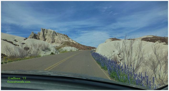
For now let’s take a drive along the 31-mile Ross Maxwell Scenic Drive, which is on the west side of the park. This route diplays all the geologic wonders that the park is famous for. It was an all-day drive for us, as there were a number of pullouts with interpretive signs that allowed us to read and learn, trailheads to follow for short and long walks, and scenic vistas. We didn’t want to miss any of them! I took so many pictures that it was difficult to choose which to post so I could best capture the experience. Here are my highlights of our drives through the park:

Tuff Canyon (below) was carved out of soft volcanic tuff or compressed ash.

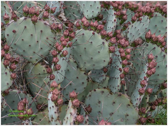
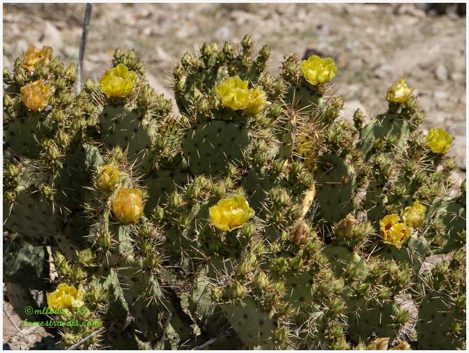
The Chihuahuan desert floor was painted with various species of blooming Prickly Pears.

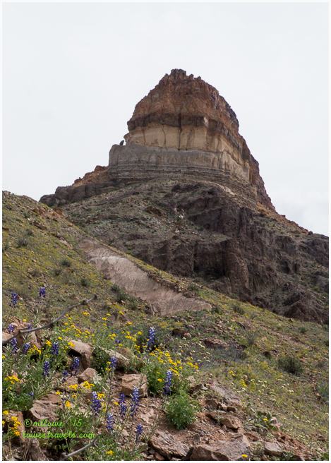
The layers we saw on the Cerro Castellan formation revealed millions of years of volcanic activity. Stacked in this tower were several lava flows and volcanic tuffs, or ash deposits.
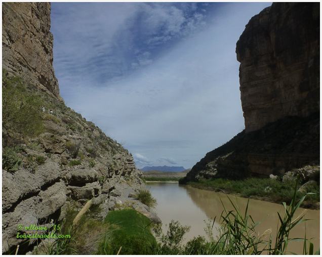
At the very end of Ross Maxwell Scenic Drive was the mouth of Santa Elena Canyon, one of Big Bend’s most scenic spots. The view from within the canyon is grand indeed. Half of the canyon is on the U.S. side, and its other 1,500 ft. south wall towers over the Mexican side of the border.

When we arrived there we were in awe, surrounded by the towering vertical cliffs of solid limestone. On the left of the canyon below is Mexico, and on the right is the U.S. side.

If you could visit only one section of the park, the Ross Maxwell Scenic Drive would be your best bet to see most of the famous, expansive vistas that mix scenery located in both Mexico and the U.S.
The east side of the park
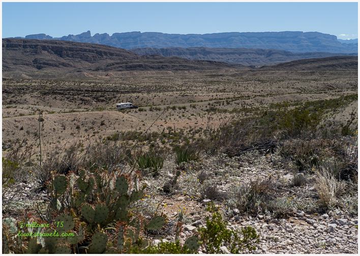
On another day we drove to the east side of the park. Here we viewed the Rio Grande flood plains looking towards Sierra del Carmen in Mexico. That rig in the picture below is on its way to Rio Grande Village RV park, the only campground in the park with full hook ups. When we saw that the campground was basically just a very small paved parking lot we were glad that it was full when we tried to make reservations. We were very happy with our spot at BJ’s RV Park in Terlingua. It was outside of Big Bend Park, but a much nicer place with access to stores and other places we wanted to visit.
The east side of the park also had river access from the U.S. to the mexican town of Boquillas. We didn’t have our passports with us, but we weren’t impressed by what we saw of the town from across the river anyway. For folks who do want to cross into Mexico for lunch, you can do so on a rowboat on Wednesdays through Sundays to visit “The Most Remote Town in Mexico”. Woohoo.
Instead, we drove a bit farther to hike into Boquillas Canyon, and we enjoyed the scenery there. The Rio Grande on the easternmost side of Big Bend National Park cuts through the Sierra del Carmen Mountains of Mexico, creating this beautiful canyon. It’s about 20 miles long, and not as deep or sheer as Santa Elena, nor as rugged as Mariscal. But it is still impressive, and worth the drive to get there.

When we got close to the entry of the canyon, we saw what we thought was a sentinel of the river. He turned out to be a mexican entrepreneur illegally selling goods across the river from his country. We heard that when the border patrol shows up, he simply gallops across the shallow river on his horse and he’s safely back in his own country!

Our final stop of the day was at Dugout Wells, where we followed the Chihuahuan Nature trail. Here I learned that it is only in the Chihuahuan desert that the Blind Prickly Pear species thrive.

This post details only our driving tours. We should mention that folks with 4-wheel drive or high-clearance vehicles can also follow the many miles of gravel roads throughout the park, to undoubtedly see many additional gorgeous sights that we couldn’t. But we did about all we could from the paved roads, and there are many more adventures from this stop that we’ll be detailing soon!

Ooooooh looks wonderful!
Ok, we now HAVE to come there next winter! Love it!
Great job. You have us so excited to visit this place. Hope we can do it next January. We will be staying at BJ’s RV Park also.
The couple that owned BJs are the best host and hostesses. They tried to make your stay comfortable.
That is great to know. Thanks.
What a beautiful post MonaLiza…I enjoyed every word and every photo!
You tell a fabulous story of Big Bend here and your photographs are just terrific. Loved the photo of the sentinal. Really perfect. Also love the one of Steve WAY up there at the top of Tuff Canyon, the one of the Rio Grand cutting through the vertical cliffs of Santa Elena Canyon and all those flowering cactus and the bluebonnets. Really wonderful. I enjoyed this so much I read it twice. Thanks so much for the information on what to see and do and most especially on where to stay. You really are a fine story teller. That last photo is a perfect way to end.
Thank you Sherry, I sure hope that one day in the future, this park will be one of your stop out west. The Big Bend area is like no other Texan terrain.
What fabulous pics of an amazing place. Love it. Thanks.
I am really impressed with this park. It does remind me of Death Valley with all the variation in physical features. I love those gorgeous canyon walls. I’m sure it was thrilling to be so little against these giants. With all the remote places you two visit, you really should look at getting a Jeep:) I’m not sure how comfortable I’d be with the Mexican border literally a stone throw away. Glad you made the out of the way trip to share this park with us:)
Yup I had planted a seed, in case our CRV dies, a jeep should be next in line. And yes there were roads we did not take that would have led us to more amazing areas.
I know that if you make this park one of your future stops, you will be glad you did. But unfortunately there are no crested saguaros in the Chihuahuan desert, just a diverse species of cacti.
I’m so happy to have you as our guide! Big Bend has been on our list for years, but as you say, it’s so remote and so huge that even though we’ve been nearby in Alpine, we didn’t feel like we could do it justice without spending at least a week there. You hit it at the perfect time with the wildflowers! Thanks for the great photo tour.
Really ? you were already in Alpine! Next time, next year put a pushpin in your map and make the park one of your stop. I guarantee your enjoyment Laurel.
WOW is right! Beautiful photos of spectacular scenery.
WooHoo! There is so much too see that a week isn’t enough! Loved the hike at Boquilla Canyon! Can’t wait to see yours. Same with E-Canyon. You have to watch out for thorns in your tires when driving! Glad you enjoyed Terlingua. It is a great little western Texas town! Hurry up, hurry up…I want to see your hiking and water adventures!
This is on my return trip list!
Wished you were here to bird with me. I think the Colima Warbler was not in town yet when we were here for I did not hear any excitement from the other birders I met.
You have peaked our interest in visiting this park. Looks fabulous! Can’t wait to read your next post on it.
What a great looking place to spend some time exploring, Mon Liza. Those prickly pears are huge. 🙂
Thanks for another fabulous tour. Seems as though you timed it perfectly with the bluebonnets in full swing. So very pretty. Glad there were no border patrol encounters 😉
Thanks for the driving tour … even without venturing far off the road, the park obviously has a lot to offer.
Oh, Boquillas does bring back memories from our college days. We got the Mexicans to take us across the river for a small fee in their little boats, long before it was an official crossing point. We all then walked to the tiny cantina and drank bottled coca colas,then walked back to the river and Le them take us back across. After the US shut down those informal crossings, the little town really struggled, since it mostly relies on tourists there. I’m glad they reopened it again but mainly for those locals that need that small amount of money to get by. It is a very depressed little town, but they truly appreciated us coming over. Great post! Makes me want to get a long trip planned to visit this area again sometime.
Yup. you have to convince yourself that Big Bend is your next destination 🙂
We really enjoyed our time at Big Bend and loved Santa Elena canyon. Looks like a great time to be there with the desert flowers in full bloom. Looking forward to seeing where you two hiked.
hu-WOW!!! Looks like THE place to visit while in Texas.