Hike them!
After being tourists in Asheville for a couple of days, we were back to what delights us the most – submerging ourselves into nature through our hiking – this time in the Blue Ridge Mountains. We were thrilled when we learned that our home base in Candler, Western NC was only 4.5 miles from the access road to the Blue Ridge Parkway. The RV park was really quaint, with only six sites and the added bonus of a creek running right through it! We will miss the sounds of that water running by the back of the rig as we enjoyed our fires and at bedtime. Steve’s review of Stony Fork Creek RV Park is here.

On the image below, numbers 1 and 2 (clicking on the numbers takes you to the related post) mark the sections of the Blue Ridge Parkway we explored last year. This time we explored the southern end of the parkway, marked number 3 below. The Blue Ridge Parkway begins at Mile 0 in Shenandoah National Park, VA and goes all the way down to Mile 469 at the Great Smoky Mountains National Park in North Carolina.

Driving out of our campsite toward our first trailhead, Steve noted an opportunity when we climbed the very curvy and steep grade up Highway 151 towards the Blue Ridge Parkway access. He blurted out that it would really be fun to coast down this curvy road on his bike. Of course, I tried to shut down his excitement by telling him it’s too dangerous and that he’s getting too old for that kind of crap. That didn’t go over very well, so I patiently reminded him that our medical coverage isn’t quite as “comprehensive” as it used to be. He admitted that was a good point.
So, bright and early the next morning he had his bike on the car, and back up the hill we went anyway. I dropped him off at the top and he waited while I located a nice sharp turn halfway down from which to witness the carnage. Since I’m no action photographer, the shot below is the best I could get as he whizzed by with a huge smile on his face. In 10 minutes he had coasted down the 4.5 miles back to our campground, and I couldn’t even catch him in the car after snapping the picture!

With that bit of insanity out of the way, we headed back for our real workout, climbing mountains. Beware, lots of mountain photos ahead.
Overlook signs and some plaques are placed along the Blue Ridge Parkway that point out and explain the interesting cultural history of that area, and ID the captivating mountain scenery. Trailheads can also be seen alongside several of the overlooks, and that’s where we began each of our hikes. During this stop, our hikes were all completed between Milepost 407 to 431 on the parkway.
Milepost 431 – Richland Balsam Hike
This is a 1.5-mile loop hike that rises about 400 feet to the summit of Richard Mountain at 6,410 feet. It is the highest peak on the Blue Ridge Parkway. At the beginning of the trail was a box that should have contained laminated self-guided tour maps to tell us what the markers along the trail were describing. But as usual it was empty, so we stopped at each marker and tried to guess what it represented. Don’t you hate it when that happens?


This was a pretty trail, and not overly strenuous. It passed through a spruce-fir forest and over the summit of the 10th highest peak in the eastern United States. The term “balsam” is commonly applied to Fraser Fir and Red Spruce trees, whose scents permeate the fresh air on the trail. This was a refreshing hike, as there was little sunlight and the forest floor was cool and moist at the high elevation.

We encountered just one cute little rabbit, who posed quite nicely for me.

After the hike, we drove north to the next overlook and found a young lady reading while enjoying this captivating vista of the Cowee mountains. The sun was not blazing that day, nor were there any crowds. So she had those mountains all to herself (well, until we showed up).

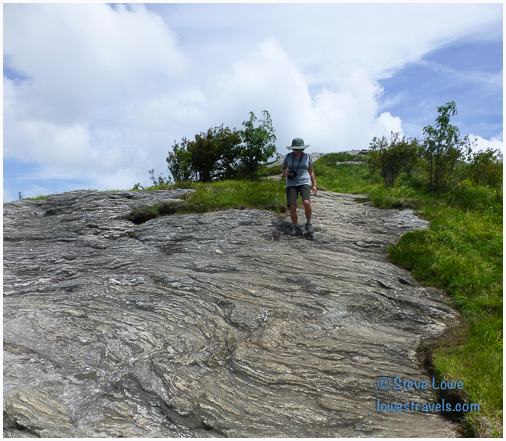
Milepost 422 – Devil’s Courthouse Hike
This hike was short, but a strenuous half-mile to the top with rewarding panoramic mountain views. The trail started from the overlook parking area beside the mountain, and was mostly paved until we approached the peak which resides at 5,720 feet. The bare-rock profile was so named because of its sinister appearance and legend, according to the sign at the overlook.

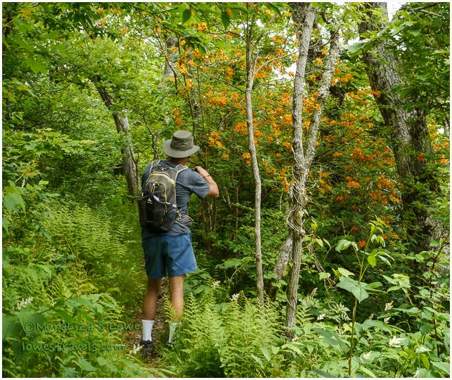
There were a few Catawba Rhododendron blooming along the trail, and the bees were just all-a-buzz about it!

There was a nice overlook at the top, and supposedly from here we could see North Carolina, South Carolina, Tennessee and Georgia. I don’t know about that, but we saw a lot!


The Devil’s Courthouse’s “devilish” look has apparently contributed to some superstitious folk tales, which is probably why someone left two plates of fresh fruits and a drink at the peak.

Milepost 420 – Black Balsam Hike
This is a very popular trail and we learned why. The Black Balsam area includes some of the most spectacular “mountain balds” in the Southern Appalachians. A mountain bald is part of a mountain range rising along the border between Tennessee and North Carolina. This one includes Black Balsam Knob, a knob being a projecting part of a mountain, usually round in shape – like a doorknob. To reach the summit of Black Balsam Knob, we hiked about 1/2 mile through the forest to reach the open, grassy and rocky mountain meadows, then we took a section of the 30-mile Art Loeb Trail. This memorial to Art Loeb, an activist from the Carolina Mountain Club, is a trail with a plaque that reads “he deeply loved these mountains.”
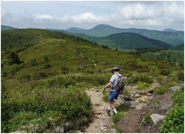
From our vantage point at Balsam Mountain, it was obvious that the Blue Ridge Parkway lives up to its name. The photo below shows a section that crests the Blue Ridge Mountains.

This trail was almost entirely devoid of trees, and we were exposed to the UV rays for several hours. The 6,214 foot Black Balsam Knob is the 23rd highest of the 40 mountains in North Carolina. It is lush and green around its top, and I could just imagine how these mountains would look in fall foliage. Hmm, it might not be a bad idea to swing back through here in October!


I can’t believe we did all of those hikes in one day – we were exhausted!
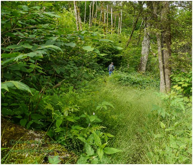
Milepost 408- Frying Pan Tower
On another day we wanted to hike to the Frying Pan Overlook Tower. Instead of taking the easy way and walking up the 3/4-mile gravel road from the Frying Pan overlook, we began this hike from Mount Pisgah so we could have a longer trek of about six miles. I’m glad we took the longer hike, for we passed many undisturbed blooming wildflowers. We could tell this trail was less-traveled, seeing nobody else as we walked through plenty of spider webs, and noticing the overgrown vegetation had not been trampled for a while. Perfect!

And just a few more pretty flowers we saw on the trail. I can’t identify the one on the left – maybe one of you can help me?


Our destination for the Frying Pan Tower hike was the 70-foot tall tower built in 1941, which I learned later is on the National Register of Historic Places. The steel tower atop the 5,340-foot Frying Pan Mountain was designed to provide extensive views to watch for fires until the early 1990s. However, hikers like us are the only ones experiencing the beauty today, not to mention the howling winds at the top.

Although the tower platform was locked, we climbed five flights of stairs to just underneath it. And wow, the view was just fantastic!


I’m exhausted just re-living these hikes, and I didn’t want it to be such a long blog. But I’m afraid there are more hikes with more beautiful scenery ahead!

Wow we are just a short distance behind you. We just finished Cades Cove and Clingmans dome. We are low land people making the walk at Clingmans a bit of a challenge with the altitude. We are leaving Waynesville NC area Monday and heading to TT at Advance NC. Your photos are great, I feel I need some lessons to even get close to you mastery.
That short hike at Clingmans dome is really a lung buster. I hope you had a clear view when you got there. Im glad too you made it at Cades Cove.
Thank you, I try to take good pictures for all my readers.
I was glad we did not have a sunny clear view except in one direction. To me the Great Smokey Mountains just fit my preconceived thought when there is a haze covering near and far. Thanks again for all your suggestions for us.
Bring em on! Looks like some great hikes, and sooooo green! We too have been having the trails almost completely to ourselves lately, it’s wonderful!
The lushness is everywhere here in the east…but you do know that the west mountains are taller and higher 🙂
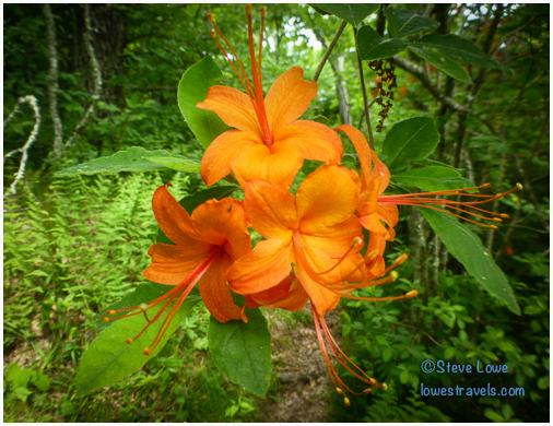
The wild flame azalea is our very very favorite. Lucky you to get to see it and GREAT picture. I really like that hike. Looks like a great campground you’ve found. Wonder how many mph What a dare devil.
Steve says thank you. He is quite happy since you mentioned the great picture of the flame azalea. He is a daredevil too, not sure how fast he went but he did the 4.5 miles in ten minutes, coasting on a curvaceous highway 151.
Oh Steve!!! Have you ever come off of one of those at 30 mph on asphalt?
Maynard http://freewheelin.me/
If I had, do you think I would be around to work on this blog? I admit it was a little scary, but fun. Nothing like the one I want to do on White Mountain in California someday – something like a 5,000′ descent over 20 miles. I’ll probably get a new bike before that one, or you’ll be reading my obituary on our blog 🙂 I hope MonaLiza does not read this!
-Steve
Thank goodness I have no problem with Al wanting to race down mtns on his bike…..I only have to worry about him jumping in a biplane doing aerobatics 😉 ML, nice to see you using your ‘big’ camera. Those orange blooms are lovely 🙂
Ingrid, the tight curves got me worried especially when the park owner told us about one motorcycle rider veering off the cliff and was not found after two days. Oh well, he made it.
And yes, Im getting out of my comfort zone and start using my big camera. I spent hours just learning that camera not to mention learning the creative part.
Next time you guys do a section of the Blue Ridge Parkway, stop at a visitor center and get a National Park map, showing the route from beginning to end. And, there is a book they sell (Guide to the Blue Ridge Parkway by Victoria Logue, Frank Logue, and Nicole Blouin) that gives history and information for the many mileposts you went by. I never tire of the BRP. We have vacationed along it’s length several times and done bits of it dozens of times. If you start at Shenandoah NP, you can add Skyline Drive. That drive has National Park lodges and coffee shops spaced along it’s length.
When we visit family in NY and MD, we often take that drive and part of the BRP on our way home to Atlanta.
Yes Holly, we did stop at a Visitor Center last year and we did explore a section of Skyline Drive too.
Like you we never tire of the parkway, it is just breathtaking here.
What wonderful hikes….I do love all the green! Why I can almost smell the pines here in Utah!
Beautiful photography MonaLiza…and Steve!
Can’t wait for more…..
That hike at Richard Balsam has pine fragrance. Love the greens here!
Haha!! John and I were laughing out loud as I read about Steve’s crazy adventure!! Great narrative, Mona:) Glad the crazy man made it safely down!
I am doing a tick search just looking at all those overgrown areas you walked through!!! But, I must admit it looked like fun:) That Flame Azalea is gorgeous!!
I like the trail in the open. Reminds me of the west. Glad you are enjoying yourselves in the mts.
Pam, I prayed for rain that day, and this time it did not arrive. Despite the park owners story about a motorcycle veering off the cliff and was not found for several days, that too, did not deter his excitement. But in the end he made it, Big exhale!
I was exhausted reading about so many hikes in one day! I really enjoyed your photos and I love the wildflower identification.
I know exhausting but worth it. I have one wildflower that I can’t identify, the little reddish one.
Hi – We are not FT RV’rs, but do own a 34′ RV and go on road trips every year. I have the BRP on my to do list. We do not pull a car, so its the parkway OK to drive through in the RV and can the overlook parking areas accomodate the RV as we stop to explore the trails? Thank you for taking the time to blog your adventures. I really enjoy reading and adding locations to my list.
Hi, most of the overlooks are wide enough to accommodate your RV. However, the parkway has several tunnels along the way. Here is a link to the tunnel clearances
http://www.blueridgeparkway.org/v.php?pg=87
and a FAQ about the parkway.
http://www.blueridgeparkway.org/v.php?pg=76
Enjoy!
You two are quite the hikers. You certainly find all the fun things to do! Beautiful area, beautiful photos as always!
Thanks Cheryl, neither one of us wants to just sit around so hike a day is like a requirement. And with the beautiful mountains surrounding us, we are more inspired.
What a super great day! Love the Blue Ridge Mts.
Yes we did enjoy, the Blue Ridge Mountains are just spectacular.
Every one of those hikes sounds wonderful. Any hikes in the east I will approach differently since Terry’s experience with ticks. As for your hubby, you have quite the daredevil there, don’t you? I could see Terry wanting to do that as well. I would be petrified to even attempt it. Great photos MonaLiza. 🙂
That Steve! He’s a daredevil isn’t he? I’ll bet you were glad to find him a the bottom of the hill with knees, elbows and head intact!
My goodness but you two have been very busy enjoying all the beauty surrounding you.
Great shot, Steve. I love Flame Azaleas. We had them at our other house.
I do believe you would not catch me on that tower. I would just send Paul up there with the camera and live with whatever photos he took.
Loved Steve’s adventurous spirit! 😀 Have you tried taking a video of action views? You can play the video and try to stop it at the right moment, copy it and turn it into image. That is actually the project I’m working on. It’s quite tricky to do but it works. Awesome images as always, Mona. Just the name Blue Ridge Mountain alone makes me want to go there. I love your tranquility shot of Cowee Mountain Overlook.
Rommel, I kept forgetting using video when Steve do crazy stuff. Next time i’ll give it a try and snap a picture from within a clip. And I know that Lightroom also has that function. The eastern mountains may not be as tall as the ones in the west but they sure are beautiful.
Your hikes look fabulous! That bike ride, not so much — I would have been terrified even watching Steve zoom down that road — but it made a great story! The flowers are so beautiful — I love that flame azalea, too.
The flame azalea was the star in that hike. I know Steve is crazy I tried to talk him out of it but failed 🙂