There was lots more to do at the Great Smoky Mountains National Park – more than I could fit into a single post. I have to say that despite going through and around the Smokies for the 10 days we were there, we barely scratched the surface. We were based near the town of Cherokee, about 5 miles from the south entrance to the park. This turned out to be a long post, so grab your favorite beverage and take your time checking out our adventures at GSMNP.
A bit of history
A visit to the Museum of the Cherokee Indians enlightened me about the plight of the Cherokee Indians in the early 1800’s. My take away from perusing through cultural and historical displays was that the Cherokee people who live in North Carolina today are referred to as the “Eastern Band of Cherokee Indians.” They are the direct descendants of those who avoided the Cherokee’s forced removal to Oklahoma in the 1830’s, also called the “Trail of Tears.” The 56,000-acre Qualla Boundary in western North Carolina adjacent to the Great Smoky Mountains National Park is their current home.


We did not encounter any live bears during our stay, but I was happy to see these critters around Cherokee that seemed harmless enough.


A Gourd Festival?
On the same day around the corner from the museum building, a Gourd Festival was in progress. I was curious, since this was the first time I had heard about this kind of festival. I saw gourds of various sizes, shapes and odd forms for sale. Crafters and gourd enthusiasts crowded the area, displaying their works of art or attending activities like hands-on gourd crafting. I was fascinated with the details and craftsmanship of the finished gourd art on display.


Hitting the trails

Lets talk hiking. I understand now why the GSMNP is also called, a “hiker’s park”. As we drove through on US 441, the main north to south scenic highway, we noticed many trailhead markers along the way. With about 150 hiking trails to choose from, we were in hiking heaven! We’d been longing for some more challenging hikes with serious elevation changes, and we weren’t disappointed here.
The hikes we chose took us deep into the forestlands. Some included breathtaking views, several ran along rushing streams with cascading waterfalls, and most were adorned with millions of wildflowers that made me stop frequently for photos.
We categorized our hikes as either waterfall, vista or wildflower hikes. Below are details of just a few of the ones we chose, and we went out almost every day to explore until our legs throbbed in pain!
Waterfall hikes
Waterfalls, streams and rivers abound in and around the park. I learned that many parts of the Smokies receive over 85″ of rainfall on average each year. All of that water trickles and then rushes down the mountainside, creating multiple waterfalls, streams and rivers. We loved the hikes that let us enjoy the sounds of water along most of their length. It is so green and lush everywhere.
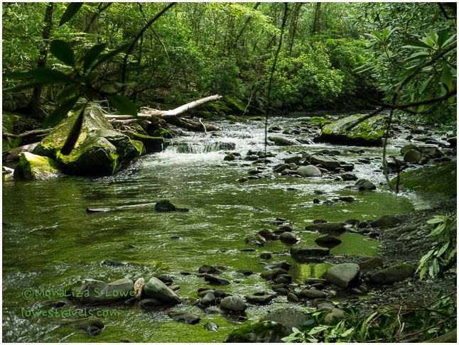


Following a three-waterfall loop from Bryson City, we came upon the Juney Whank, Indian Creek and Tom Branch falls. How often do you get to see three beautiful waterfalls on one hike? We also saw several others along our driving route that day.

To reach Mingo Falls, we followed a 0.4 mile trail that included steep wooden stairs, and we were out of breath by the time we reached the top. At 120′ tall, this is one of the tallest and most spectacular waterfalls in the Smoky Mountains.
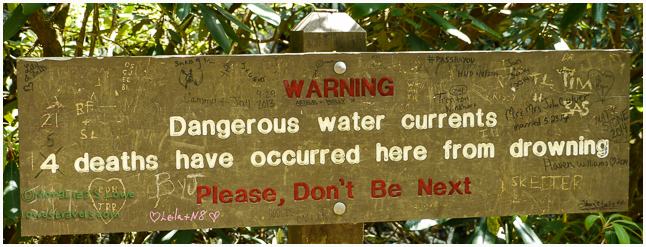
The hike to Abram Falls was about five miles roundtrip. The waterfall itself was only 20′ high, but a long and deep pool at its base creates strong currents beneath the falls. The strong undertow there was responsible for the deaths of several people.
Wildflower hikes
The Smokies explode with wildflowers during the springtime months. It is commonly referred to as “The Wildflower National Park.” But alas, we missed many of the beauties by arriving a bit late in the season. The best time to see the hillsides carpeted with colors is April and May, but I managed to snap a few leftovers on some of the trails where the wildflowers were abundant.


To catch a few of those remaining spring wildflowers, we followed the Oconaluftee River Trail, an easy 3-mile roundtrip that began at the Oconaluftee Visitor Center and ran alongside the river. Next, we followed the 6.2-mile Smokemont Loop Trail and burned some calories on its 1,400′ ascent through creekside cove hardwood forests and drier oak- and hickory-dominated ridge tops. I was able to see a few blooms and can identify only a few and marked some with a (?).


The Icewater Shelter Trail (5.4 miles) was our first true taste of serious mountain hiking, since this trail ascends quite steeply at the beginning. Parts of it are very rocky with large boulders, and other sections follow smoother ridge lines. A few clamps of Bluets were swaying in the breeze along this trail. It is a section of the Appalachian Trail that goes to the outcropping at Charles Bunion.

Vista Hikes
The vista hikes we did were real “lung busters” and calf toners, with rewards of great panoramic mountain views. The .5-mile ascent to Clingman’s Dome, which I mentioned on my previous post, gave us a 360-degree view of the Smokies. Outside the park we tackled Whiteside Mountain in the Nantahala Forest. This mountain is a distinct landmark along the eastern Continental Divide for aviators and ground-bound folks alike. The 2-mile trail is rated difficult because of its steepness and switchbacks, which include steps placed to help negotiate the rocky slope. At the top we had a great view of South Carolina and the face of this mountain, which is prized by rock climbers. It was closed to those folks while we were there because it was nesting season for the Perigrine Falcons that return there every year.

A 1.2-mile roundtrip hike to the summit at Waterrock Knob was a steep climb, gaining 412 feet in elevation. This trail begins at Milepost 451.2 on the Blue Ridge Parkway, just 18 miles from where the parkway ends at the Great Smoky Mountains Visitors Center (Milepost 469).


After completing all of these hikes, we believe the calories we’d been carrying since leaving Florida were finally melting away, and our hiking muscles were coming back – yay! But most of all, we felt really good and reinvigorated from being back to nature and far from the noises of civilization.

Scenic Drives
Although hiking might be the best way to enjoy the park, scenic drives are also available to those who prefer to view the mountains from the comfort of their car. In between our hiking days we took the suggested drives to Cade’s Cove Loop and the Roaring Fork Motor Nature Trail, which were about 56 miles from our home base in Cherokee. We also checked out the nearby Road to Nowhere in Bryson City. 
The most popular drive, with bumper-to-bumper traffic on a one-lane 11-mile loop road, was Cade’s Cove. A “cove” in the mountains is a flat valley between mountains or ridges. Cades Cove used to be a farming community in the early 1900’s, and today this is a showcase of natural and cultural treasures preserved for generations to come.

As we drove here, we saw preserved pastureland, churches, preserved structures and some wildlife. We never saw a bear, but this cute deer caused a traffic jam on the one-way street.


As the name suggests, the Roaring Form Motor Nature Trail is a nature trail viewable from your car. As we drove the 6-mile-long, one-way loop road we were essentially following Roaring Fork Creek, a stream within a series of rushing cascades. There were access points to waterfall trails, but we just drove on the road enjoying the forest. The beautiful green scenery and sounds of rushing water was so soothing that I was afraid Steve would fall asleep while driving.


The Road to Nowhere

We learned about this drive from the packet of “Off the Beaten Path” information that our RV park hostess gave us. The road was originally named Lakeview Drive, but since it was never completed the residents called it “The Road to Nowhere.” In 1943 the federal government promised to build it for access to the Fontana Dam, as compensation to local residents who gave up their land for the project. Approximated 6 miles of the road, including a bridge and 1200-foot tunnel, were completed by end of 1969, but the remaining 26 miles was never finished. It is a nice scenic drive from Bryson City into GSMNP, where it dead-ends.

The tunnel is closed to car traffic and can only be walked through on foot. Midway through it, I grabbed Steve’s hand as it was a bit scary walking in the dark – even though we could see light at the distant end.

While walking around Bryson City we stumbled upon a local brewery – a perfect way to end our long day of auto touring.


Back at the campground, our feathered friends provided us with entertainment as we relaxed after each long day in the mountains.


And that wraps up our magnificent and glorious stay at the mountains. We feel that we made the most of our time with a close-up experience of the best, nature has to offer in the Smokies.
Resources:
Park Map
Click to access grsmmap2-2.pdf
Trail Map
Click to access trail-map_JULY13-full.pdf
For more information, visit The Great Smoky Mountain National Park’s Website!

Great post. I love the smokies and drove up through to Shenandoah a number of years back. Your pictures are beautiful–brought back many memories. Thank you.
Glad you liked it, for we liked and enjoyed the Smokies too.
What a great resource for those, like Joe and I, who plan a visit to the Smokies. Your pictures are gorgeous MonaLiza…they sure “invite” you to visit there.
The two little birds are so sweet! I miss the birds…haven’t seen that many here in Moab.
Gay, you and Joe will get both a workout and up close encounter with nature. The rewards are reachable. So far the birdies are still around entertaining us. Not sure as we continue to head up north.
Your hikes look absolutely wonderful! I love the combination of a great workout together with the calming nature of beautiful vistas and waterfalls. That combo completely sends me to euphoria! (If that’s a place :-)). Well done!
The Smokies is quite unique, almost all hiking trails has its reward either at the end or along the trail, just Beautiful!
What timing – We just arrived at the Smokies area today at Sevierville Tn.. We are here for a Suites rally but added 4 extra days. Now I can tell 4 days is not near enough and may have to look for other parks. Your post is our guide, thanks!
Hope you guys are enjoying the Smokies as much as we did.
Having lived in Virginia nearly all my life, I’ve been to GSMNP many many times and it just isn’t possible to see everything you want to see no matter how many times you go. But boy you guys really gave it an all out effort. And you showed me something I never knew – the road to nowhere. What a rip off to the folks whose land was taken. Sounds like what happened in the Shenandoah National Park. Really gorgeous pictures. It is such a fantastically beautiful place and you captured it wonderfully.
Yup, it was a rip off for these people losing their land and what a waste of money. But on the flip side, they make it into an attraction so that at least we get to explore that part of the area. There was actually a hike there that would have taken us to Fontana Dam but we did not. It was late and I don’t want to walk back into that tunnel in the dark.
yes, we loved our time in the Smokies…
It’s amazing how much there is to do there! Absolutely gorgeous photos, I LOVE all the green. That last stream picture is incredible.
Thank you Lisa, our mountains are as beautiful as the ones on the west 🙂 naah, the west are more spectacular!
That was us on the motorcycle taking a few of those roads (a few years ago). We’ve never hiked the GSMNP but it sure does make for some great motorcycle riding. Maybe someday we will have the desire to try hitting some more trails in the east. I love that young buck with his new antlers:) The waterfalls are always a thrill. So glad you are getting back in hiking shape while waiting for your Gaffney appointment:)
Pam, every time we encounter a motorcycle I never fail to say, look, there’s John and Pam! I could not ask for more, WNC is the best place to kill time and get in shape, so many hikes! This Friday is already our appointment.
That was a grand tour of the Smokies! Beautiful landscape shots and wildflowers. Like you guys, we’re happy to be doing lots of hiking again after our four month stay in Florida this winter — but our hikes here out west look very different from the lush greenery and waterfalls you’re experiencing (as you know). How are the temperatures and humidity?
Laurel, it sure is really different here but the greenery is something that you guys are missing. We stunk after each hike 😦 although most hikes are done under trees.
That is sure some beautiful country. Places like that with so much to see and do caused us to start the volunteering thing in order to be stationary for a while. Works for us. We may have to check out some of those parts for down the road.
I would say ten days were not enough, too much to do. But you may not enjoy it as you are having a great time with better looking mountains in high altitudes.
What an amazing time you two had. I would have loved to attend the Gourd Festival. I make pine needle baskets. Many of my fellow weavers use gourds as the base of their basket. I would have enjoyed seeing all the creations.
I love the flower photos. There are so many different varieties in that area. Gorgeous.
I like the way you divided up your hikes. I’ll use this post as a good reference when we hopefully get back in that area. Possibly early this fall. Thanks.
Marsha, there were 10 tables with groups working on their crafts and some were lessons too. Their joy working on their art was fascinating.
Oh how neat. I would have loved to take a lesson.
Fantastic … we stayed in Gatlinburg when we went to the Smokies back in the 90s for a few days … and came out at Cherokee, from where we detoured to Asheville and Chimney Rock State Park. The latter was home to the filming from of some of the scenes from The Last of the Mohicans. Our second trip was a Phaeton trip in mid April 2012 … we stayed in the much quieter Townsend area to focus our trip on and around Cades Cove; the wildflowers were just blooming, so maybe late April/early May would have been optimum for flowers. Then again, we had fewer crowds, and we got to enjoy sightings of just awakening black bears … so can’t really complain about our timing.
Erin, we drove too Gatlinburg and found it a busy city compared to Cherokee. If Cades Cove had been closer to us we could have gone earlier and catch the bears hanging on trees.
I wish I could double-like your post, Mona. The pics are absolutely stunning, from the cute bear sculptures to the breathtaking mountain views. Those two birds are hilarious. The one on the left looks like the nagging wife. 🙂 The Red Cardinal is very handsome indeed. I bet those beers went down so well after your busy day.
Those fledgelings asking for food was really endearing and fun to watch. They nag their moms every afternoon.
Great post ML! I especially like your flower photo gallery!
Thanks Carol, if Steve did not stop me I could have shown all of my wildflowers! 🙂
Awesome pictures. I enjoy hiking anywhere, but especially the forests with waterfalls. Your description along with the photos lets the imagination run wild. Thanks again for sharing a wonderful place to visit.
Thanks, we really had a great time at the Smokies.
Beautiful photos, ML. (Just visiting your blog cooled me off – I miss the green and the rain, and rivers….. it’s been HOT here in AZ). Happy trails…. -M
Good, glad somehow the coolness and lushness has reached you in AZ, Maureen.
It has been so many years since we have been to the Smokies and your post certainly brought it alive for us again. So fabulous to be getting back out in nature again, away from the big cities and feel the cool mountain air bathing your lungs. You two really went after it on the hiking trails and got some gorgeous photos in the process. 🙂
Thanks LuAnn, we certainly made up for the months we could not get a real hike.
You made me google gourd festival to see more pictures of finish products. As it turns out, they have Gourd Festival in San Diego this month as well. Hmmm … I’ll definitely keep that in mind. Thanks for the knowledge, Mona. Blogosphere is a hellova classroom. 😀 Triple awesome captures, Mona. The birds are just hu-WOW!
Thanks Rommel and Im looking forward to photos of Gourd Art!