We saw a video describing Chiricahua National Monument at the Kartchner Caverns visitor’s center, and it piqued our interest. We had not previously heard about “The Land of Standing up Rocks” as referred to by the local Chiricahua Apaches, and the “Wonderland of Rocks” by later pioneers. After seeing it, we simply call it the “Gorgeous giant rock concert.” We opted to stay in Arizona a couple extra days to check it out and moved Betsy over to Willcox, a little closer and still on our way.
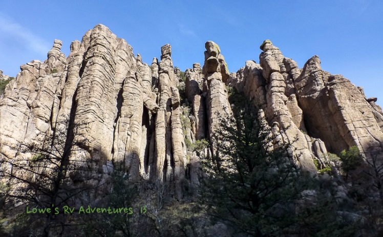
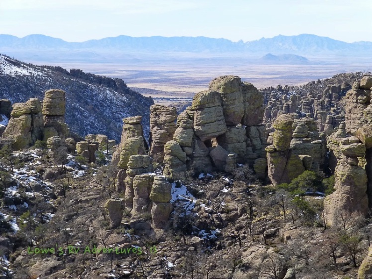
Chiricahua (pronounced CHEER-IH-COW-AH) National Monument, established in 1924, is described as a sky island – an isolated mountain range rising above a surrounding grassland sea. The unusual rock formations here were caused by a massive volcanic eruption some 27 million years ago by the nearby Turkey Creek caldera, which covered the land with white-hot ash. As the ash cooled, it fused into dark volcanic rock known today as rhyolite. The continual natural erosion via water and wind has sculpted these rocks and split them into tall columns, pinnacles and unlikely balancing rocks. We have seen many rock formations in our travels (like the ones at Alabama Hills in Lone Pine, California), but here in the Chiricahua Mountains the outcroppings are something to behold!
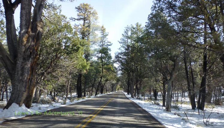
The eight mile scenic trip along Bonita Canyon Drive made a fairly steep ascent through oak, cypress and pine forest until we arrived at Massai Point, where the road terminates and several hiking trails begin. Along the way there are pull outs where we could stop to view and photograph some amazing formations, such as the Organ Pipe Formation, Sea Captain and China Boy.
Hiking is the best option for getting up close and personal with the extensive outcrops of the eroded volcanic pinnacles. We thought about taking the Heart of Rocks Loop, where a group of impressive and unusual rock formations can be viewed. But due to recent snow and the trail being classified as strenuous, the park ranger did not recommend it at this time. Instead, we settled on the Echo Canyon Trail, and tackled the 3.3 circuit which begins at Massai Point at 6780′ elevation.

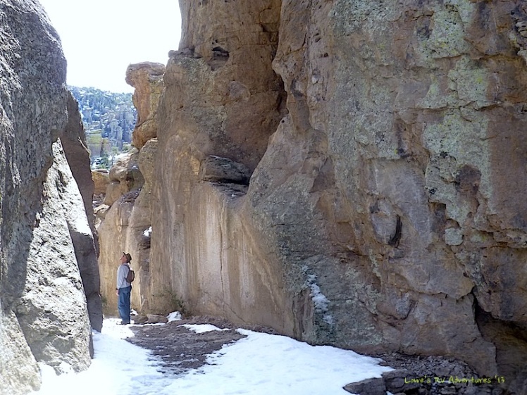
The Echo Canyon Trail is the second most popular path in Chiricahua National Monument. It follows a rocky ridge past many huge eroded boulders, balanced rocks and at this time held a lot of snow and ice! The trail was slick and slippery, and it took us about 3 hours to complete the loop. But it was well worth it! We walked amongst the grottoes and balanced rocks, which is actually a bit unsettling, as you realize these massive boulders over your head could come down and smash you like a bug if there was even a small earthquake.


At one point we passed through a narrow, sheer-walled passage called Wall Street.
Then the path descended to the forested floor of a sheltered valley called Echo Park, which was at this time covered with snow and very beautiful.
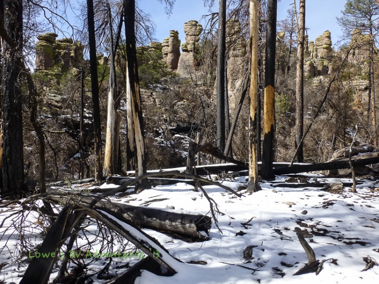
Continuing on the trail we rounded a corner to a grand viewpoint high above two deep ravines, and on to a junction with the Hailstone and Upper Rhyolite Canyon trails. On this north-facing side of the trail the snow had melted so we picked up our pace, walking along the base of the pinnacles lining the Rhyolite Canyon.

Along this trail we stopped and admired the many eroded boulders that are seemingly ready to fall. The lichen-covered columns and pinnacles were colored green and/or orange.


There are 17 miles of hiking trails that intersect in the park, but the best option for an all day hike is known as the Big Loop, a 9.5 mile trip to all areas of the various formations. The Chiricahua mountains was worth our change of plans, what a fantastic place!
We discovered while in Willcox that there are a few vineyards that grow and bottle yummy wines, and they are seriously good! Two have tasting rooms in town – Keeling Schaefer and Coronado Vineyards. We missed the wineries at Patagonia, so went tasting here and were surprised by the quality of these southwestern wines. It was a fitting end to our Arizona wanderings.
Farewell, Arizona, until next time!


Looks like you had a great hike. We will be there in Mid March. Did you notice any good boondocking areas that are close to the park?
Hmm that I am unsure of or I dont know. The CNM is really out of the way and takes only less than 29′ RVs. We stayed at Sagebrush RV/Mobile home park 😦
When you go be sure to take the Big Loop Hike.
Oh check this out http://freecampsites.net/indian-bread-rocks/
What amazing rock groupings!! I love them! How cool to be able to do a little hiking in the snow! It looked like your hike took you through two different seasons. You did an excellent job capturing all the different rock poses. Definitely rocks in concert.
Yet another place to add to the list. It will take years to see all the beauty in the west.
Safe travels to your next stop. Where are you headed?
Hiking in the snow was tricky and very slow to avoid landind on our butts. We dont carry hiking sticks so it was slow.
Exactly, I dont think we can even see everything. Luckily we have blogs to share so we can see what we missed or will miss.
We are eastbound and currently in NM.
Your photography, as always, is so stunning. You have given us some great ideas for places to visit and hikes to take when we head further south next month. Thanks so much and safe travels. 🙂
Oh thank you LuAnn. I urge you to take the Big Loop Hike if not the Hearts of Rock trail, so i can see what we missed.
We will try to do that. Thanks again for all the great ideas. 🙂
Looks like a wonderful place, I can’t wait till we get there!
Yeah, and when you do take the Big Loop hike and start early.
Looks like Goblin Valley or Bryce Canyon in Southern Utah except the color is different. I want to go there. Enjoy!
I think you should make a trip here for comparison.
OK then… We just put this on our “must see” list when we visit the part of AZ in late Feb. Great info and great photos! Thanks.
Thank you, This is an out of the way monument but really really a cool place.
I must say you are a very good picture taker. love your posts. I have lived in Arizona all my life and never heard of this place with the standing rocks. thanks Brenda
Ohh thank you.I think the park is not well promoted but it is really a great place to visit. Its a 120 miles from Tucson.
A great way to end your tour of AZ! Rock on you two! Where will you go next? 🙂
Yup we rocked out of AZ and heading east now in NM.
I’m surprised you let a ‘little’ snow stop you from that hike….lol. Thanks for reminding me of this place. Looks like a must see and followed by wine tasting….doesn’t get much better. Safe travels!
Even if you have seen already more colorful rock formation than these, I would urge you to stop by. The only downside is that the park can only take no more than 29 ft vehicle. The priv RV park here is not really that great.
I cannot find my jaw again. It seems to have dropped somewhere.
Thanks Rommel, this place should be on your bucket list.
Wow. What is that white stuff on the ground? 80 degrees or more here this week….
Seriously, what a gorgeous place. Love the wine glasses too!
I know we had some cold days and nights on our last days in AZ.
So happy to see your write up of this beautiful place. Another rocky wonderland to add to our bucket list. We have been to Bryce, Zion, Goblin Valley, Yosemite, Devil’s Postpile National Monument, Yellowstone Nat’l Park, Icefields Parkway in Alberta, Canada and we love looking at fantastic rock “concerts.” (Great description by the way!)
This is going on our bucket list.
You did the place justice with your photos!
Susan
Thank you. This place seems need some advertising, for it is really out of the way and 120 miles east of Tucson. Wow you had been to many places maybe you can tells us more about it. We will be in San Antonio 2/15-2/20.
We’d love to meet you. Where will you be staying?
Most of the places on our list were before full-timing (except Yellowstone) and we’d love to share our experiences with you. I’m sure you have many to share as well.
Susan & Bob
We will be at Traveler’s World RV Resort. Will send you message for our meeting once we settled in. Thanks
That’s where we are too. Won’t be too hard to meet! LOL.
That is so funny. Ha ha , So how do you like the park?
We have been here on and off since July and we like the park. Some of the spaces are very crowded, like where we are right now and our last space. The sites in the back of the park and most of the pull-through sites are more spacious. The management of the park is awesome and the grounds, laundry and restrooms are kept very clean. During the snowbird season there are a number of activities to do in the park.
The neighborhood around the park looks scary, but we’ve never had a problem. There is security at the park.
If you like being close to downtown and a great bike/walking path then this park is great for that. On of the entrances to a new extension of the Riverwalk is right outside the front entrance to the park.
Be careful which was you drive to the park. We recommend you take I-35 to Military Rd., then go east on Military Road about two miles to Roosevelt and turn north on Roosevelt. Those are the best roads to the park. DO NOT take Southcross…there is a very steep railroad crossing grade. Trust us, you would not want to go that way. Plus Southcross is very uneven. Try driving it in your car while you’re here and you’ll see what we mean.
Anyway, we have made the park our home for a while as Bob has a good job in San Antonio.
I just recently hiked the same loop! It is so beautiful there… and a little humbling as it makes one feel very small. Great pictures!
Thank you, so true. If not for the snow we could have done the other trails.